Wahroonga geodata
Wahroonga (New South Wales) is a section of populated place; located in Australia in Australia/Sydney (GMT+11) time zone. With population of 17,652 people, there are 207 cities with bigger population in this country. Compared to other cities in Australia, 50.9% of cities are located further ↓South; 70.4% of cities are located further ←West and 82.2% of cities have lower elevation than Wahroonga. Note1


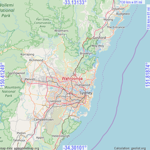
Wahroonga GPS coordinates[2]
33° 43' 5.376" South, 151° 6' 56.196" East
| Map corner | latitude | longitude |
|---|---|---|
| Upper-left | -33.13133°, | 150.41249° |
| Center: | -33.71816°, | 151.11561° |
| Lower-right: | -34.30101°, | 151.81874° |
| Map W x H: | 130.1×130.1 km | = 80.8×80.8mi |
| max Lat: | -10.58257° ⇑49.1% North |
| Wahroonga: | -33.71816° |
| min Lat: | ⇓50.9% South -43.31423° |
| min Long | Wahroonga | max Long |
| 113.53327° | 151.11561° | 153.61246° |
| W 70.4%⇐ | ⇒29.6% E |
Elevation
Elevation of Wahroonga is 206 m = 676 ft, and this is 84 m = 276 ft above average elevation for this country.
| Max E: |
1715 m = 5627 ft | 17.8% |
| Wahroonga | 206 m 676 ft | |
| Avg. | 122 m = 400 ft | |
Min E: |
-2 m = -7 ft | 82.2% |
See also: Australia elevation on elevation.city.
Geographical zone
Wahroonga is located in South temperate zone (between Tropic of Capricorn and the Antarctic Circle). Distance of this Southern Tropic circle is 1143.2 km =710.4 mi to North.| Distance of | km | miles | from Wahroonga |
|---|---|---|---|
| Equator | 3749.1 | 2329.6 | to North |
| Tropic Capricorn | 1143.2 | 710.4 | to North |
| Antarctic Circle | 3652.1 | 2269.3 | to South |
| South Pole | 6258 | 3888.5 | to South |


Nearby cities:
15 places around Wahroonga: (largest is in red/bold)
• Asquith
3.5 km =2.2 mi,  1°
1°
• Hornsby
2.3 km =1.4 mi,  319°
319°
• Mount Colah
3.9 km =2.4 mi, 1°
• Normanhurst
1.9 km =1.2 mi,  251°
251°
• North Turramurra
2.9 km =1.8 mi,  78°
78°
• North Wahroonga
1.6 km =1 mi,  24°
24°
• Pennant Hills
4.6 km =2.9 mi,  241°
241°
• Pymble
3.8 km =2.4 mi,  139°
139°
• Saint Ives
4.3 km =2.7 mi,  107°
107°
• South Turramurra
3.5 km =2.2 mi,  184°
184°
• Thornleigh
3.7 km =2.3 mi, 245°
• Turramurra
2.1 km =1.3 mi, 144°
• Waitara
1.4 km =0.9 mi,  305°
305°
• Warrawee
1.3 km =0.8 mi,  159°
159°
• Westleigh
4.2 km =2.6 mi,  279°
279°
Sources, notices
• [Note1] Compared only with cities in Australia existing in our database
• [Src1] Map data: © OpenStreetMap contributors (CC-BY-SA)
• [Src2] Other city data from geonames.org with taken over terms of usage.
• [Src3] Geographical zone / Annual Mean Temperature by Robert A. Rohde @ Wikipedia
