Asquith geodata
Asquith (New South Wales) is a section of populated place; located in Australia in Australia/Sydney (GMT+11) time zone. With population of 3,347 people, there are 2050 cities with bigger population in this country. Compared to other cities in Australia, 51.5% of cities are located further ↓South; 70.4% of cities are located further ←West and 78.9% of cities have lower elevation than Asquith. Note1


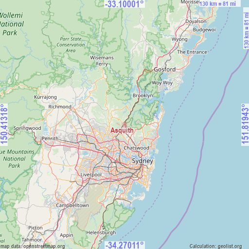
Asquith GPS coordinates[2]
33° 41' 13.38" South, 151° 6' 58.68" East
| Map corner | latitude | longitude |
|---|---|---|
| Upper-left | -33.10001°, | 150.41318° |
| Center: | -33.68705°, | 151.1163° |
| Lower-right: | -34.27011°, | 151.81943° |
| Map W x H: | 130.1×130.1 km | = 80.8×80.8mi |
| max Lat: | -10.58257° ⇑48.5% North |
| Asquith: | -33.68705° |
| min Lat: | ⇓51.5% South -43.31423° |
| min Long | Asquith | max Long |
| 113.53327° | 151.1163° | 153.61246° |
| W 70.4%⇐ | ⇒29.6% E |
Elevation
Elevation of Asquith is 167 m = 548 ft, and this is 45 m = 148 ft above average elevation for this country.
| Max E: |
1715 m = 5627 ft | 21.1% |
| Asquith | 167 m 548 ft | |
| Avg. | 122 m = 400 ft | |
Min E: |
-2 m = -7 ft | 78.9% |
See also: Australia elevation on elevation.city.
Geographical zone
Asquith is located in South temperate zone (between Tropic of Capricorn and the Antarctic Circle). Distance of this Southern Tropic circle is 1139.7 km =708.2 mi to North.| Distance of | km | miles | from Asquith |
|---|---|---|---|
| Equator | 3745.6 | 2327.4 | to North |
| Tropic Capricorn | 1139.7 | 708.2 | to North |
| Antarctic Circle | 3655.5 | 2271.4 | to South |
| South Pole | 6261.4 | 3890.7 | to South |


Nearby cities:
15 places around Asquith: (largest is in red/bold)
• Hornsby
2.3 km =1.4 mi,  222°
222°
• Hornsby Heights
2.7 km =1.7 mi,  310°
310°
• Mount Colah
0.4 km =0.2 mi,  4°
4°
• Mount Kuring-Gai
5.1 km =3.2 mi,  12°
12°
• Normanhurst
4.5 km =2.8 mi,  204°
204°
• North Turramurra
4 km =2.5 mi,  136°
136°
• North Wahroonga
2.1 km =1.3 mi,  163°
163°
• Saint Ives
6.2 km =3.9 mi, 139°
• St Ives Chase
4.8 km =3 mi,  112°
112°
• Thornleigh
6.1 km =3.8 mi,  214°
214°
• Turramurra
5.3 km =3.3 mi,  167°
167°
• Wahroonga
3.5 km =2.2 mi,  181°
181°
• Waitara
2.9 km =1.8 mi, 204°
• Warrawee
4.7 km =2.9 mi, 175°
• Westleigh
5 km =3.1 mi,  236°
236°
Sources, notices
• [Note1] Compared only with cities in Australia existing in our database
• [Src1] Map data: © OpenStreetMap contributors (CC-BY-SA)
• [Src2] Other city data from geonames.org with taken over terms of usage.
• [Src3] Geographical zone / Annual Mean Temperature by Robert A. Rohde @ Wikipedia
