Westleigh geodata
Westleigh (New South Wales) is a section of populated place; located in Australia in Australia/Sydney (GMT+11) time zone. With population of 4,335 people, there are 1670 cities with bigger population in this country. Compared to other cities in Australia, 51% of cities are located further ↓South; 69% of cities are located further ←West and 78% of cities have lower elevation than Westleigh. Note1


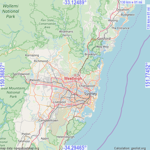
Westleigh GPS coordinates[2]
33° 42' 42.336" South, 151° 4' 17.004" East
| Map corner | latitude | longitude |
|---|---|---|
| Upper-left | -33.12489°, | 150.36827° |
| Center: | -33.71176°, | 151.07139° |
| Lower-right: | -34.29465°, | 151.77452° |
| Map W x H: | 130.1×130.1 km | = 80.8×80.8mi |
| max Lat: | -10.58257° ⇑49% North |
| Westleigh: | -33.71176° |
| min Lat: | ⇓51% South -43.31423° |
| min Long | Westleigh | max Long |
| 113.53327° | 151.07139° | 153.61246° |
| W 69%⇐ | ⇒31% E |
Elevation
Elevation of Westleigh is 156 m = 512 ft, and this is 34 m = 112 ft above average elevation for this country.
| Max E: |
1715 m = 5627 ft | 22% |
| Westleigh | 156 m 512 ft | |
| Avg. | 122 m = 400 ft | |
Min E: |
-2 m = -7 ft | 78% |
See also: Australia elevation on elevation.city.
Geographical zone
Westleigh is located in South temperate zone (between Tropic of Capricorn and the Antarctic Circle). Distance of this Southern Tropic circle is 1142.5 km =709.9 mi to North.| Distance of | km | miles | from Westleigh |
|---|---|---|---|
| Equator | 3748.4 | 2329.1 | to North |
| Tropic Capricorn | 1142.5 | 709.9 | to North |
| Antarctic Circle | 3652.8 | 2269.7 | to South |
| South Pole | 6258.7 | 3889 | to South |


Nearby cities:
15 places around Westleigh: (largest is in red/bold)
• Asquith
5 km =3.1 mi,  56°
56°
• Beecroft
4.2 km =2.6 mi,  188°
188°
• Cherrybrook
2.6 km =1.6 mi,  244°
244°
• Hornsby
2.8 km =1.7 mi,  68°
68°
• Hornsby Heights
5 km =3.1 mi,  25°
25°
• Mount Colah
5.2 km =3.2 mi,  52°
52°
• Normanhurst
2.6 km =1.6 mi,  120°
120°
• North Epping
5.6 km =3.5 mi,  159°
159°
• North Wahroonga
4.8 km =3 mi,  81°
81°
• Pennant Hills
2.9 km =1.8 mi,  178°
178°
• Thornleigh
2.4 km =1.5 mi, 162°
• Wahroonga
4.2 km =2.6 mi,  99°
99°
• Waitara
3 km =1.9 mi,  88°
88°
• Warrawee
4.9 km =3 mi,  112°
112°
• West Pennant Hills
4.4 km =2.7 mi,  210°
210°
Sources, notices
• [Note1] Compared only with cities in Australia existing in our database
• [Src1] Map data: © OpenStreetMap contributors (CC-BY-SA)
• [Src2] Other city data from geonames.org with taken over terms of usage.
• [Src3] Geographical zone / Annual Mean Temperature by Robert A. Rohde @ Wikipedia
