Normanhurst geodata
Normanhurst (New South Wales) is a section of populated place; located in Australia in Australia/Sydney (GMT+11) time zone. With population of 5,211 people, there are 1422 cities with bigger population in this country. Compared to other cities in Australia, 50.7% of cities are located further ↓South; 69.8% of cities are located further ←West and 79.8% of cities have lower elevation than Normanhurst. Note1


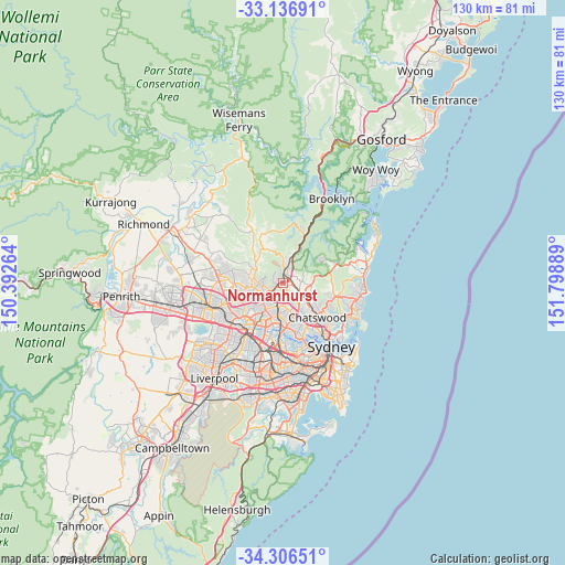
Normanhurst GPS coordinates[2]
33° 43' 25.32" South, 151° 5' 44.736" East
| Map corner | latitude | longitude |
|---|---|---|
| Upper-left | -33.13691°, | 150.39264° |
| Center: | -33.7237°, | 151.09576° |
| Lower-right: | -34.30651°, | 151.79889° |
| Map W x H: | 130×130 km | = 80.8×80.8mi |
| max Lat: | -10.58257° ⇑49.3% North |
| Normanhurst: | -33.7237° |
| min Lat: | ⇓50.7% South -43.31423° |
| min Long | Normanhurst | max Long |
| 113.53327° | 151.09576° | 153.61246° |
| W 69.8%⇐ | ⇒30.2% E |
Elevation
Elevation of Normanhurst is 178 m = 584 ft, and this is 56 m = 184 ft above average elevation for this country.
| Max E: |
1715 m = 5627 ft | 20.2% |
| Normanhurst | 178 m 584 ft | |
| Avg. | 122 m = 400 ft | |
Min E: |
-2 m = -7 ft | 79.8% |
See also: Australia elevation on elevation.city.
Geographical zone
Normanhurst is located in South temperate zone (between Tropic of Capricorn and the Antarctic Circle). Distance of this Southern Tropic circle is 1143.8 km =710.7 mi to North.| Distance of | km | miles | from Normanhurst |
|---|---|---|---|
| Equator | 3749.7 | 2330 | to North |
| Tropic Capricorn | 1143.8 | 710.7 | to North |
| Antarctic Circle | 3651.5 | 2268.9 | to South |
| South Pole | 6257.3 | 3888.1 | to South |


Nearby cities:
15 places around Normanhurst: (largest is in red/bold)
• Asquith
4.5 km =2.8 mi,  24°
24°
• Beecroft
4.1 km =2.5 mi,  224°
224°
• Cherrybrook
4.6 km =2.9 mi,  272°
272°
• Hornsby
2.4 km =1.5 mi,  7°
7°
• North Epping
4 km =2.5 mi,  184°
184°
• North Turramurra
4.8 km =3 mi,  75°
75°
• North Wahroonga
3.2 km =2 mi,  50°
50°
• Pennant Hills
2.7 km =1.7 mi,  234°
234°
• South Turramurra
3.3 km =2.1 mi,  151°
151°
• Thornleigh
1.8 km =1.1 mi,  238°
238°
• Turramurra
3.2 km =2 mi,  109°
109°
• Wahroonga
1.9 km =1.2 mi,  71°
71°
• Waitara
1.6 km =1 mi,  26°
26°
• Warrawee
2.4 km =1.5 mi,  104°
104°
• Westleigh
2.6 km =1.6 mi,  300°
300°
Sources, notices
• [Note1] Compared only with cities in Australia existing in our database
• [Src1] Map data: © OpenStreetMap contributors (CC-BY-SA)
• [Src2] Other city data from geonames.org with taken over terms of usage.
• [Src3] Geographical zone / Annual Mean Temperature by Robert A. Rohde @ Wikipedia
