Niddrie geodata
Niddrie (Victoria) is a section of populated place; located in Australia in Australia/Melbourne (GMT+11) time zone. With population of 5,443 people, there are 1360 cities with bigger population in this country. Compared to other cities in Australia, 85.7% of cities are located further ↑North; 68% of cities are located further →East and 62.1% of cities have lower elevation than Niddrie. Note1


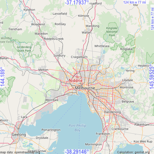
Niddrie GPS coordinates[2]
37° 44' 15" South, 144° 53' 31.632" East
| Map corner | latitude | longitude |
|---|---|---|
| Upper-left | -37.17937°, | 144.189° |
| Center: | -37.7375°, | 144.89212° |
| Lower-right: | -38.29146°, | 145.59525° |
| Map W x H: | 123.7×123.7 km | = 76.9×76.9mi |
| max Lat: | -10.58257° ⇑85.7% North |
| Niddrie: | -37.7375° |
| min Lat: | ⇓14.3% South -43.31423° |
| min Long | Niddrie | max Long |
| 113.53327° | 144.89212° | 153.61246° |
| W 32%⇐ | ⇒68% E |
Elevation
Elevation of Niddrie is 70 m = 230 ft, and this is 52 m = 171 ft below average elevation for this country.
| Max E: |
1715 m = 5627 ft | 37.9% |
| Avg. | 122 m = 400 ft | |
| Niddrie | 70 m = 230 ft | |
Min E: |
-2 m = -7 ft | 62.1% |
See also: Australia elevation on elevation.city.
Geographical zone
Niddrie is located in South temperate zone (between Tropic of Capricorn and the Antarctic Circle). Distance of this Southern Tropic circle is 1590.1 km =988 mi to North.| Distance of | km | miles | from Niddrie |
|---|---|---|---|
| Equator | 4196 | 2607.3 | to North |
| Tropic Capricorn | 1590.1 | 988 | to North |
| Antarctic Circle | 3205.2 | 1991.6 | to South |
| South Pole | 5811 | 3610.8 | to South |


Nearby cities:
15 places around Niddrie: (largest is in red/bold)
• Aberfeldie
2.5 km =1.6 mi,  169°
169°
• Airport West
1.7 km =1.1 mi,  326°
326°
• Avondale Heights
3.7 km =2.3 mi,  224°
224°
• Essendon
2.1 km =1.3 mi,  129°
129°
• Essendon North
1.3 km =0.8 mi,  114°
114°
• Essendon West
2.1 km =1.3 mi,  201°
201°
• Gowanbrae
3.3 km =2.1 mi,  357°
357°
• Keilor East
2.4 km =1.5 mi,  282°
282°
• Keilor Park
3.8 km =2.4 mi,  299°
299°
• Maribyrnong
3.9 km =2.4 mi,  189°
189°
• Moonee Ponds
3.9 km =2.4 mi,  146°
146°
• Oak Park
3.2 km =2 mi,  48°
48°
• Pascoe Vale
3.7 km =2.3 mi,  82°
82°
• Strathmore
2.5 km =1.6 mi,  85°
85°
• Strathmore Heights
2.7 km =1.7 mi,  8°
8°
Sources, notices
• [Note1] Compared only with cities in Australia existing in our database
• [Src1] Map data: © OpenStreetMap contributors (CC-BY-SA)
• [Src2] Other city data from geonames.org with taken over terms of usage.
• [Src3] Geographical zone / Annual Mean Temperature by Robert A. Rohde @ Wikipedia
