Fountaindale geodata
Fountaindale (New South Wales) is a section of populated place; located in Australia in Australia/Sydney (GMT+11) time zone. With population of 692 people, there are 4337 cities with bigger population in this country. Compared to other cities in Australia, 55.1% of cities are located further ↓South; 76.8% of cities are located further ←West and 71.1% of cities have lower elevation than Fountaindale. Note1


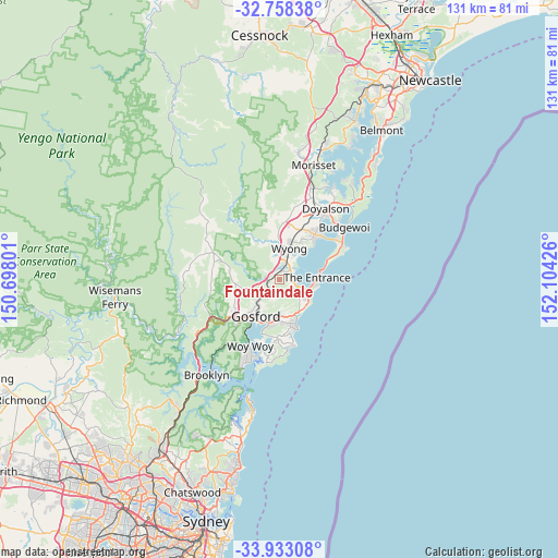
Fountaindale GPS coordinates[2]
33° 20' 51.756" South, 151° 24' 4.068" East
| Map corner | latitude | longitude |
|---|---|---|
| Upper-left | -32.75838°, | 150.69801° |
| Center: | -33.34771°, | 151.40113° |
| Lower-right: | -33.93308°, | 152.10426° |
| Map W x H: | 130.6×130.6 km | = 81.2×81.2mi |
| max Lat: | -10.58257° ⇑44.9% North |
| Fountaindale: | -33.34771° |
| min Lat: | ⇓55.1% South -43.31423° |
| min Long | Fountaindale | max Long |
| 113.53327° | 151.40113° | 153.61246° |
| W 76.8%⇐ | ⇒23.2% E |
Elevation
Elevation of Fountaindale is 109 m = 358 ft, and this is 13 m = 43 ft below average elevation for this country.
| Max E: |
1715 m = 5627 ft | 28.9% |
| Avg. | 122 m = 400 ft | |
| Fountaindale | 109 m = 358 ft | |
Min E: |
-2 m = -7 ft | 71.1% |
See also: Australia elevation on elevation.city.
Geographical zone
Fountaindale is located in South temperate zone (between Tropic of Capricorn and the Antarctic Circle). Distance of this Southern Tropic circle is 1102 km =684.8 mi to North.| Distance of | km | miles | from Fountaindale |
|---|---|---|---|
| Equator | 3707.9 | 2304 | to North |
| Tropic Capricorn | 1102 | 684.8 | to North |
| Antarctic Circle | 3693.3 | 2294.9 | to South |
| South Pole | 6299.1 | 3914.1 | to South |


Nearby cities:
15 places around Fountaindale: (largest is in red/bold)
• Bateau Bay
7.3 km =4.5 mi,  123°
123°
• Berkeley Vale
3 km =1.9 mi,  94°
94°
• Chittaway Bay
3.5 km =2.2 mi,  50°
50°
• Chittaway Point
4.6 km =2.9 mi, 54°
• Glenning Valley
2.4 km =1.5 mi,  105°
105°
• Holgate
6 km =3.7 mi,  166°
166°
• Killarney Vale
5.6 km =3.5 mi, 108°
• Lisarow
5.1 km =3.2 mi,  218°
218°
• Mardi
6 km =3.7 mi,  0°
0°
• Niagara Park
5.8 km =3.6 mi,  236°
236°
• Ourimbah
7.6 km =4.7 mi,  299°
299°
• Tuggerah
5.2 km =3.2 mi,  29°
29°
• Tumbi Vmbi
5 km =3.1 mi, 114°
• Wyoming
7.2 km =4.5 mi,  209°
209°
• Wyong
7.5 km =4.7 mi,  15°
15°
Sources, notices
• [Note1] Compared only with cities in Australia existing in our database
• [Src1] Map data: © OpenStreetMap contributors (CC-BY-SA)
• [Src2] Other city data from geonames.org with taken over terms of usage.
• [Src3] Geographical zone / Annual Mean Temperature by Robert A. Rohde @ Wikipedia
