Mardi geodata
Mardi (New South Wales) is a section of populated place; located in Australia in Australia/Sydney (GMT+11) time zone. With population of 3,648 people, there are 1937 cities with bigger population in this country. Compared to other cities in Australia, 55.5% of cities are located further ↓South; 76.9% of cities are located further ←West and 79% of cities have higher elevation than Mardi. Note1


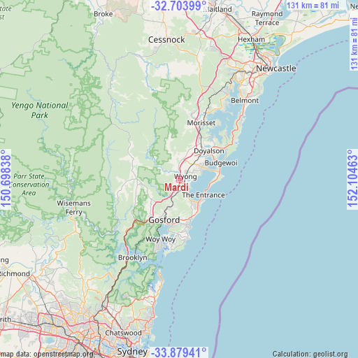
Mardi GPS coordinates[2]
33° 17' 37.248" South, 151° 24' 5.4" East
| Map corner | latitude | longitude |
|---|---|---|
| Upper-left | -32.70399°, | 150.69838° |
| Center: | -33.29368°, | 151.4015° |
| Lower-right: | -33.87941°, | 152.10463° |
| Map W x H: | 130.7×130.7 km | = 81.2×81.2mi |
| max Lat: | -10.58257° ⇑44.5% North |
| Mardi: | -33.29368° |
| min Lat: | ⇓55.5% South -43.31423° |
| min Long | Mardi | max Long |
| 113.53327° | 151.4015° | 153.61246° |
| W 76.9%⇐ | ⇒23.1% E |
Elevation
Elevation of Mardi is 16 m = 52 ft, and this is 106 m = 348 ft below average elevation for this country.
| Max E: |
1715 m = 5627 ft | 79% |
| Avg. | 122 m = 400 ft | |
| Mardi | 16 m = 52 ft | |
Min E: |
-2 m = -7 ft | 21% |
See also: Australia elevation on elevation.city.
Geographical zone
Mardi is located in South temperate zone (between Tropic of Capricorn and the Antarctic Circle). Distance of this Southern Tropic circle is 1096 km =681 mi to North.| Distance of | km | miles | from Mardi |
|---|---|---|---|
| Equator | 3701.9 | 2300.3 | to North |
| Tropic Capricorn | 1096 | 681 | to North |
| Antarctic Circle | 3699.3 | 2298.6 | to South |
| South Pole | 6305.2 | 3917.9 | to South |


Nearby cities:
15 places around Mardi: (largest is in red/bold)
• Berkeley Vale
6.9 km =4.3 mi,  154°
154°
• Chittaway Bay
4.6 km =2.9 mi, 145°
• Chittaway Point
5 km =3.1 mi,  131°
131°
• Fountaindale
6 km =3.7 mi,  180°
180°
• Glenning Valley
7.1 km =4.4 mi,  160°
160°
• Hamlyn Terrace
8.4 km =5.2 mi,  55°
55°
• Jilliby
7.7 km =4.8 mi,  10°
10°
• Ourimbah
7 km =4.3 mi,  250°
250°
• Tacoma
5.7 km =3.5 mi,  83°
83°
• Tuggerah
2.9 km =1.8 mi,  119°
119°
• Tuggerawong
7.5 km =4.7 mi, 78°
• Wadalba
6.4 km =4 mi,  68°
68°
• Warnervale
7 km =4.3 mi,  41°
41°
• Watanobbi
3.5 km =2.2 mi,  34°
34°
• Wyong
2.4 km =1.5 mi, 58°
Sources, notices
• [Note1] Compared only with cities in Australia existing in our database
• [Src1] Map data: © OpenStreetMap contributors (CC-BY-SA)
• [Src2] Other city data from geonames.org with taken over terms of usage.
• [Src3] Geographical zone / Annual Mean Temperature by Robert A. Rohde @ Wikipedia
