Toongabbie geodata
Toongabbie (New South Wales) is a section of populated place; located in Australia in Australia/Sydney (GMT+11) time zone. With population of 14,218 people, there are 305 cities with bigger population in this country. Compared to other cities in Australia, 51.4% of cities are located further ↑North; 66.6% of cities are located further ←West and 55.9% of cities have higher elevation than Toongabbie. Note1


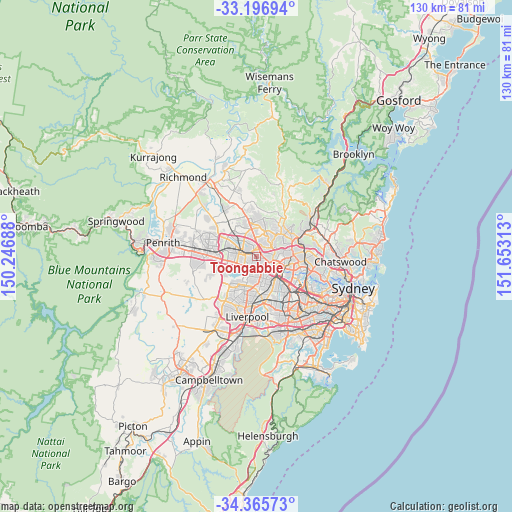
Toongabbie GPS coordinates[2]
33° 46' 59.988" South, 150° 57' 0" East
| Map corner | latitude | longitude |
|---|---|---|
| Upper-left | -33.19694°, | 150.24688° |
| Center: | -33.78333°, | 150.95° |
| Lower-right: | -34.36573°, | 151.65313° |
| Map W x H: | 130×130 km | = 80.8×80.8mi |
| max Lat: | -10.58257° ⇑51.4% North |
| Toongabbie: | -33.78333° |
| min Lat: | ⇓48.6% South -43.31423° |
| min Long | Toongabbie | max Long |
| 113.53327° | 150.95° | 153.61246° |
| W 66.6%⇐ | ⇒33.4% E |
Elevation
Elevation of Toongabbie is 37 m = 121 ft, and this is 85 m = 279 ft below average elevation for this country.
| Max E: |
1715 m = 5627 ft | 55.9% |
| Avg. | 122 m = 400 ft | |
| Toongabbie | 37 m = 121 ft | |
Min E: |
-2 m = -7 ft | 44.1% |
See also: Australia elevation on elevation.city.
Geographical zone
Toongabbie is located in South temperate zone (between Tropic of Capricorn and the Antarctic Circle). Distance of this Southern Tropic circle is 1150.4 km =714.8 mi to North.| Distance of | km | miles | from Toongabbie |
|---|---|---|---|
| Equator | 3756.4 | 2334.1 | to North |
| Tropic Capricorn | 1150.4 | 714.8 | to North |
| Antarctic Circle | 3644.8 | 2264.8 | to South |
| South Pole | 6250.7 | 3884 | to South |


Nearby cities:
15 places around Toongabbie: (largest is in red/bold)
• Blacktown
3.6 km =2.2 mi,  301°
301°
• Constitution Hill
2.6 km =1.6 mi,  112°
112°
• Girraween
1.9 km =1.2 mi,  200°
200°
• Greystanes
4.5 km =2.8 mi,  184°
184°
• Kings Langley
3.9 km =2.4 mi,  339°
339°
• Lalor Park
3 km =1.9 mi,  325°
325°
• Northmead
4.5 km =2.8 mi,  90°
90°
• Old Toongabbie
1.8 km =1.1 mi, 105°
• Pendle Hill
2.4 km =1.5 mi,  167°
167°
• Prospect
3.9 km =2.4 mi,  238°
238°
• Seven Hills
1.5 km =0.9 mi,  270°
270°
• South Wentworthville
4.1 km =2.5 mi,  162°
162°
• Wentworthville
3.1 km =1.9 mi,  147°
147°
• Westmead
4.2 km =2.6 mi,  123°
123°
• Winston Hills
2.9 km =1.8 mi,  74°
74°
Sources, notices
• [Note1] Compared only with cities in Australia existing in our database
• [Src1] Map data: © OpenStreetMap contributors (CC-BY-SA)
• [Src2] Other city data from geonames.org with taken over terms of usage.
• [Src3] Geographical zone / Annual Mean Temperature by Robert A. Rohde @ Wikipedia
