Toogoom geodata
Toogoom (Queensland) is a populated place; located in Australia in Australia/Brisbane (GMT+10) time zone. With population of 2,138 people, there are 2799 cities with bigger population in this country. Compared to other cities in Australia, 89.5% of cities are located further ↓South; 85.8% of cities are located further ←West and 98.8% of cities have higher elevation than Toogoom. Note1


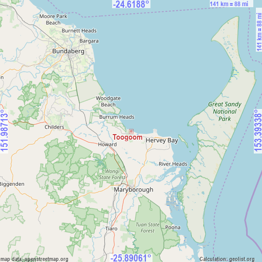
Toogoom GPS coordinates[2]
25° 15' 22.932" South, 152° 41' 24.9" East
| Map corner | latitude | longitude |
|---|---|---|
| Upper-left | -24.6188°, | 151.98713° |
| Center: | -25.25637°, | 152.69025° |
| Lower-right: | -25.89061°, | 153.39338° |
| Map W x H: | 141.4×141.4 km | = 87.9×87.9mi |
| max Lat: | -10.58257° ⇑10.5% North |
| Toogoom: | -25.25637° |
| min Lat: | ⇓89.5% South -43.31423° |
| min Long | Toogoom | max Long |
| 113.53327° | 152.69025° | 153.61246° |
| W 85.8%⇐ | ⇒14.2% E |
Elevation
Elevation of Toogoom is 3 m = 10 ft, and this is 119 m = 390 ft below average elevation for this country.
| Max E: |
1715 m = 5627 ft | 98.8% |
| Avg. | 122 m = 400 ft | |
| Toogoom | 3 m = 10 ft | |
Min E: |
-2 m = -7 ft | 1.2% |
See also: Australia elevation on elevation.city.
Geographical zone
Toogoom is located in South temperate zone (between Tropic of Capricorn and the Antarctic Circle). Distance of this Southern Tropic circle is 202.3 km =125.7 mi to North.| Distance of | km | miles | from Toogoom |
|---|---|---|---|
| Equator | 2808.2 | 1744.9 | to North |
| Tropic Capricorn | 202.3 | 125.7 | to North |
| Antarctic Circle | 4592.9 | 2853.9 | to South |
| South Pole | 7198.8 | 4473.1 | to South |


Nearby cities:
15 places around Toogoom: (largest is in red/bold)
• Burrum Heads
11.2 km =7 mi,  315°
315°
• Craignish
4.5 km =2.8 mi,  130°
130°
• Dundowran
9.5 km =5.9 mi,  117°
117°
• Dundowran Beach
7.4 km =4.6 mi,  101°
101°
• Eli Waters
12.2 km =7.6 mi, 102°
• Hervey Bay
8.7 km =5.4 mi,  113°
113°
• Howard
14.9 km =9.3 mi,  241°
241°
• Nikenbah
13.4 km =8.3 mi, 121°
• Pacific Haven
13.9 km =8.6 mi,  265°
265°
• Pialba
15.8 km =9.8 mi, 102°
• Point Vernon
12.8 km =8 mi,  90°
90°
• Sunshine Acres
15 km =9.3 mi,  139°
139°
• Takura
6.9 km =4.3 mi,  175°
175°
• Torbanlea
13.8 km =8.6 mi,  224°
224°
• Urraween
13.9 km =8.6 mi, 108°
Sources, notices
• [Note1] Compared only with cities in Australia existing in our database
• [Src1] Map data: © OpenStreetMap contributors (CC-BY-SA)
• [Src2] Other city data from geonames.org with taken over terms of usage.
• [Src3] Geographical zone / Annual Mean Temperature by Robert A. Rohde @ Wikipedia
