Howard geodata
Howard (Queensland) is a populated place; located in Australia in Australia/Brisbane (GMT+10) time zone. With population of 1,332 people, there are 3446 cities with bigger population in this country. Compared to other cities in Australia, 89.1% of cities are located further ↓South; 84.8% of cities are located further ←West and 76.1% of cities have higher elevation than Howard. Note1


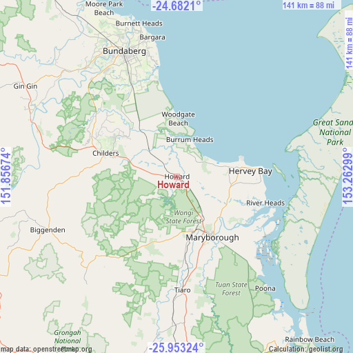
Howard GPS coordinates[2]
25° 19' 9.624" South, 152° 33' 35.496" East
| Map corner | latitude | longitude |
|---|---|---|
| Upper-left | -24.6821°, | 151.85674° |
| Center: | -25.31934°, | 152.55986° |
| Lower-right: | -25.95324°, | 153.26299° |
| Map W x H: | 141.3×141.3 km | = 87.8×87.8mi |
| max Lat: | -10.58257° ⇑10.9% North |
| Howard: | -25.31934° |
| min Lat: | ⇓89.1% South -43.31423° |
| min Long | Howard | max Long |
| 113.53327° | 152.55986° | 153.61246° |
| W 84.8%⇐ | ⇒15.2% E |
Elevation
Elevation of Howard is 18 m = 59 ft, and this is 104 m = 341 ft below average elevation for this country.
| Max E: |
1715 m = 5627 ft | 76.1% |
| Avg. | 122 m = 400 ft | |
| Howard | 18 m = 59 ft | |
Min E: |
-2 m = -7 ft | 23.9% |
See also: Australia elevation on elevation.city.
Geographical zone
Howard is located in South temperate zone (between Tropic of Capricorn and the Antarctic Circle). Distance of this Southern Tropic circle is 209.3 km =130.1 mi to North.| Distance of | km | miles | from Howard |
|---|---|---|---|
| Equator | 2815.2 | 1749.3 | to North |
| Tropic Capricorn | 209.3 | 130.1 | to North |
| Antarctic Circle | 4585.9 | 2849.5 | to South |
| South Pole | 7191.8 | 4468.8 | to South |


Nearby cities:
15 places around Howard: (largest is in red/bold)
• Aldershot
19.1 km =11.9 mi,  146°
146°
• Burrum Heads
15.9 km =9.9 mi,  19°
19°
• Craignish
17 km =10.6 mi,  76°
76°
• Dundowran
21.7 km =13.5 mi, 82°
• Dundowran Beach
21.1 km =13.1 mi,  74°
74°
• Hervey Bay
21.4 km =13.3 mi, 80°
• Maryborough West
23.3 km =14.5 mi, 152°
• Nikenbah
24.5 km =15.2 mi,  90°
90°
• Oakhurst
22.8 km =14.2 mi,  160°
160°
• Pacific Haven
6 km =3.7 mi,  352°
352°
• Sunshine Acres
23.3 km =14.5 mi,  100°
100°
• Takura
13.7 km =8.5 mi, 89°
• Toogoom
14.9 km =9.3 mi,  61°
61°
• Torbanlea
4.5 km =2.8 mi,  130°
130°
• Woodgate
23.5 km =14.6 mi,  0°
0°
Sources, notices
• [Note1] Compared only with cities in Australia existing in our database
• [Src1] Map data: © OpenStreetMap contributors (CC-BY-SA)
• [Src2] Other city data from geonames.org with taken over terms of usage.
• [Src3] Geographical zone / Annual Mean Temperature by Robert A. Rohde @ Wikipedia
