Burrum Heads geodata
Burrum Heads (Queensland) is a populated place; located in Australia in Australia/Brisbane (GMT+10) time zone. With population of 2,222 people, there are 2747 cities with bigger population in this country. Compared to other cities in Australia, 89.5% of cities are located further ↓South; 85.1% of cities are located further ←West and 98.8% of cities have higher elevation than Burrum Heads. Note1


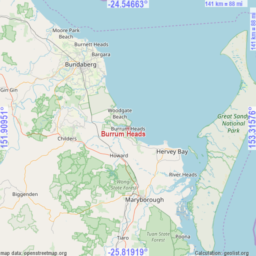
Burrum Heads GPS coordinates[2]
25° 11' 4.452" South, 152° 36' 45.468" East
| Map corner | latitude | longitude |
|---|---|---|
| Upper-left | -24.54663°, | 151.90951° |
| Center: | -25.18457°, | 152.61263° |
| Lower-right: | -25.81919°, | 153.31576° |
| Map W x H: | 141.5×141.5 km | = 87.9×87.9mi |
| max Lat: | -10.58257° ⇑10.5% North |
| Burrum Heads: | -25.18457° |
| min Lat: | ⇓89.5% South -43.31423° |
| min Long | Burrum Heads | max Long |
| 113.53327° | 152.61263° | 153.61246° |
| W 85.1%⇐ | ⇒14.9% E |
Elevation
Elevation of Burrum Heads is 3 m = 10 ft, and this is 119 m = 390 ft below average elevation for this country.
| Max E: |
1715 m = 5627 ft | 98.8% |
| Avg. | 122 m = 400 ft | |
| Burrum Heads | 3 m = 10 ft | |
Min E: |
-2 m = -7 ft | 1.2% |
See also: Australia elevation on elevation.city.
Geographical zone
Burrum Heads is located in South temperate zone (between Tropic of Capricorn and the Antarctic Circle). Distance of this Southern Tropic circle is 194.3 km =120.7 mi to North.| Distance of | km | miles | from Burrum Heads |
|---|---|---|---|
| Equator | 2800.3 | 1740 | to North |
| Tropic Capricorn | 194.3 | 120.7 | to North |
| Antarctic Circle | 4600.9 | 2858.9 | to South |
| South Pole | 7206.8 | 4478.1 | to South |


Nearby cities:
15 places around Burrum Heads: (largest is in red/bold)
• Craignish
15.6 km =9.7 mi,  134°
134°
• Dundowran
20.3 km =12.6 mi, 127°
• Dundowran Beach
17.8 km =11.1 mi,  122°
122°
• Eli Waters
22.4 km =13.9 mi, 118°
• Hervey Bay
19.5 km =12.1 mi, 126°
• Howard
15.9 km =9.9 mi,  199°
199°
• Nikenbah
24.4 km =15.2 mi, 127°
• Pacific Haven
10.9 km =6.8 mi,  213°
213°
• Point Vernon
22.1 km =13.7 mi,  111°
111°
• Redridge
25.3 km =15.7 mi,  273°
273°
• Takura
17 km =10.6 mi,  150°
150°
• Toogoom
11.2 km =7 mi,  135°
135°
• Torbanlea
18 km =11.2 mi,  186°
186°
• Urraween
24.4 km =15.2 mi, 120°
• Woodgate
9.9 km =6.2 mi,  329°
329°
Sources, notices
• [Note1] Compared only with cities in Australia existing in our database
• [Src1] Map data: © OpenStreetMap contributors (CC-BY-SA)
• [Src2] Other city data from geonames.org with taken over terms of usage.
• [Src3] Geographical zone / Annual Mean Temperature by Robert A. Rohde @ Wikipedia
