Thangool geodata
Thangool (Queensland) is a populated place; located in Australia in Australia/Brisbane (GMT+10) time zone. With population of 761 people, there are 4223 cities with bigger population in this country. Compared to other cities in Australia, 90.5% of cities are located further ↓South; 59.3% of cities are located further ←West and 81.7% of cities have lower elevation than Thangool. Note1


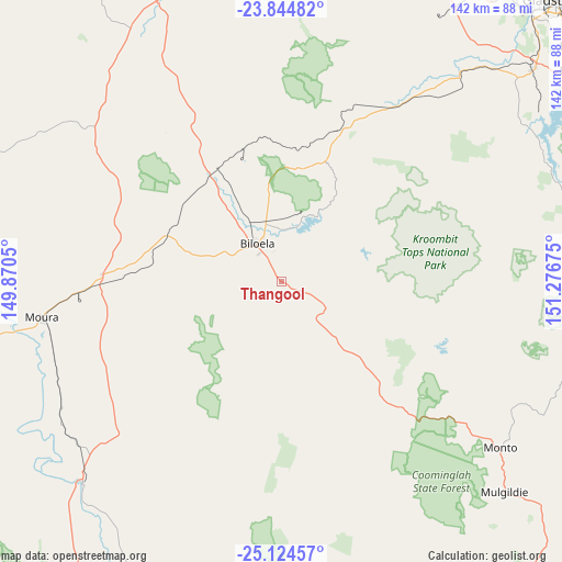
Thangool GPS coordinates[2]
24° 29' 10.752" South, 150° 34' 25.032" East
| Map corner | latitude | longitude |
|---|---|---|
| Upper-left | -23.84482°, | 149.8705° |
| Center: | -24.48632°, | 150.57362° |
| Lower-right: | -25.12457°, | 151.27675° |
| Map W x H: | 142.3×142.3 km | = 88.4×88.4mi |
| max Lat: | -10.58257° ⇑9.5% North |
| Thangool: | -24.48632° |
| min Lat: | ⇓90.5% South -43.31423° |
| min Long | Thangool | max Long |
| 113.53327° | 150.57362° | 153.61246° |
| W 59.3%⇐ | ⇒40.7% E |
Elevation
Elevation of Thangool is 201 m = 659 ft, and this is 79 m = 259 ft above average elevation for this country.
| Max E: |
1715 m = 5627 ft | 18.3% |
| Thangool | 201 m 659 ft | |
| Avg. | 122 m = 400 ft | |
Min E: |
-2 m = -7 ft | 81.7% |
See also: Australia elevation on elevation.city.
Geographical zone
Thangool is located in South temperate zone (between Tropic of Capricorn and the Antarctic Circle). Distance of this Southern Tropic circle is 116.7 km =72.5 mi to North.| Distance of | km | miles | from Thangool |
|---|---|---|---|
| Equator | 2722.6 | 1691.7 | to North |
| Tropic Capricorn | 116.7 | 72.5 | to North |
| Antarctic Circle | 4678.6 | 2907.1 | to South |
| South Pole | 7284.4 | 4526.3 | to South |


Nearby cities:
15 places around Thangool: (largest is in red/bold)
• Beecher
91 km =56.5 mi,  44°
44°
• Benaraby
93.9 km =58.3 mi,  55°
55°
• Biloela
11.7 km =7.3 mi,  329°
329°
• Burua
88.4 km =54.9 mi,  47°
47°
• Calliope
82.9 km =51.5 mi, 50°
• Clinton
94.3 km =58.6 mi, 43°
• Kin Kora
96.2 km =59.8 mi, 45°
• Kirkwood
93.3 km =58 mi, 45°
• Monto
69.6 km =43.2 mi,  127°
127°
• Mount Morgan
95.4 km =59.3 mi,  348°
348°
• Moura
62.1 km =38.6 mi,  261°
261°
• New Auckland
94.9 km =59 mi, 45°
• Telina
95.8 km =59.5 mi, 46°
• Theodore
71.8 km =44.6 mi,  224°
224°
• West Stowe
85.2 km =52.9 mi, 41°
Sources, notices
• [Note1] Compared only with cities in Australia existing in our database
• [Src1] Map data: © OpenStreetMap contributors (CC-BY-SA)
• [Src2] Other city data from geonames.org with taken over terms of usage.
• [Src3] Geographical zone / Annual Mean Temperature by Robert A. Rohde @ Wikipedia
