Rockbank geodata
Rockbank (Victoria) is a section of populated place; located in Australia in Australia/Melbourne (GMT+11) time zone. With population of 1,571 people, there are 3215 cities with bigger population in this country. Compared to other cities in Australia, 85.6% of cities are located further ↑North; 69.6% of cities are located further →East and 69.2% of cities have lower elevation than Rockbank. Note1


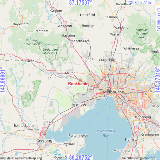
Rockbank GPS coordinates[2]
37° 44' 0.708" South, 144° 40' 12.108" East
| Map corner | latitude | longitude |
|---|---|---|
| Upper-left | -37.17537°, | 143.96691° |
| Center: | -37.73353°, | 144.67003° |
| Lower-right: | -38.28752°, | 145.37316° |
| Map W x H: | 123.7×123.7 km | = 76.9×76.9mi |
| max Lat: | -10.58257° ⇑85.6% North |
| Rockbank: | -37.73353° |
| min Lat: | ⇓14.4% South -43.31423° |
| min Long | Rockbank | max Long |
| 113.53327° | 144.67003° | 153.61246° |
| W 30.4%⇐ | ⇒69.6% E |
Elevation
Elevation of Rockbank is 98 m = 322 ft, and this is 24 m = 79 ft below average elevation for this country.
| Max E: |
1715 m = 5627 ft | 30.8% |
| Avg. | 122 m = 400 ft | |
| Rockbank | 98 m = 322 ft | |
Min E: |
-2 m = -7 ft | 69.2% |
See also: Australia elevation on elevation.city.
Geographical zone
Rockbank is located in South temperate zone (between Tropic of Capricorn and the Antarctic Circle). Distance of this Southern Tropic circle is 1589.7 km =987.8 mi to North.| Distance of | km | miles | from Rockbank |
|---|---|---|---|
| Equator | 4195.6 | 2607 | to North |
| Tropic Capricorn | 1589.7 | 987.8 | to North |
| Antarctic Circle | 3205.6 | 1991.9 | to South |
| South Pole | 5811.5 | 3611.1 | to South |


Nearby cities:
15 places around Rockbank: (largest is in red/bold)
• Albanvale
8.8 km =5.5 mi,  99°
99°
• Burnside
7.5 km =4.7 mi, 103°
• Burnside Heights
7.3 km =4.5 mi,  84°
84°
• Caroline Springs
5.9 km =3.7 mi, 98°
• Deer Park
9.3 km =5.8 mi,  113°
113°
• Delahey
9.6 km =6 mi, 80°
• Hillside
7.9 km =4.9 mi,  52°
52°
• Kings Park
9.5 km =5.9 mi,  90°
90°
• Kurunjang
9.1 km =5.7 mi,  314°
314°
• Melton
9.3 km =5.8 mi, 306°
• Melton South
8.8 km =5.5 mi,  288°
288°
• Plumpton
5.5 km =3.4 mi,  19°
19°
• Ravenhall
8 km =5 mi,  116°
116°
• Sydenham
9.3 km =5.8 mi,  66°
66°
• Taylors Hill
7.9 km =4.9 mi, 70°
Sources, notices
• [Note1] Compared only with cities in Australia existing in our database
• [Src1] Map data: © OpenStreetMap contributors (CC-BY-SA)
• [Src2] Other city data from geonames.org with taken over terms of usage.
• [Src3] Geographical zone / Annual Mean Temperature by Robert A. Rohde @ Wikipedia
