Table Top geodata
Table Top (New South Wales) is a section of populated place; located in Australia in Australia/Sydney (GMT+11) time zone. With population of 1,372 people, there are 3393 cities with bigger population in this country. Compared to other cities in Australia, 78.3% of cities are located further ↑North; 53.1% of cities are located further →East and 85.1% of cities have lower elevation than Table Top. Note1


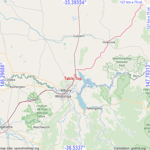
Table Top GPS coordinates[2]
35° 58' 0.012" South, 147° 0' 0" East
| Map corner | latitude | longitude |
|---|---|---|
| Upper-left | -35.39554°, | 146.29688° |
| Center: | -35.96667°, | 147° |
| Lower-right: | -36.5337°, | 147.70313° |
| Map W x H: | 126.6×126.6 km | = 78.7×78.7mi |
| max Lat: | -10.58257° ⇑78.3% North |
| Table Top: | -35.96667° |
| min Lat: | ⇓21.7% South -43.31423° |
| min Long | Table Top | max Long |
| 113.53327° | 147° | 153.61246° |
| W 46.9%⇐ | ⇒53.1% E |
Elevation
Elevation of Table Top is 248 m = 814 ft, and this is 126 m = 413 ft above average elevation for this country.
| Max E: |
1715 m = 5627 ft | 14.9% |
| Table Top | 248 m 814 ft | |
| Avg. | 122 m = 400 ft | |
Min E: |
-2 m = -7 ft | 85.1% |
See also: Australia elevation on elevation.city.
Geographical zone
Table Top is located in South temperate zone (between Tropic of Capricorn and the Antarctic Circle). Distance of this Southern Tropic circle is 1393.2 km =865.7 mi to North.| Distance of | km | miles | from Table Top |
|---|---|---|---|
| Equator | 3999.1 | 2484.9 | to North |
| Tropic Capricorn | 1393.2 | 865.7 | to North |
| Antarctic Circle | 3402.1 | 2114 | to South |
| South Pole | 6007.9 | 3733.1 | to South |


Nearby cities:
15 places around Table Top: (largest is in red/bold)
• Albury
13.8 km =8.6 mi,  209°
209°
• Bonegilla
19.3 km =12 mi,  178°
178°
• East Albury
14.2 km =8.8 mi, 206°
• Gerogery
14.7 km =9.1 mi,  357°
357°
• Glenroy
12.3 km =7.6 mi,  220°
220°
• Hamilton Valley
10.8 km =6.7 mi, 223°
• Jindera
10.1 km =6.3 mi,  277°
277°
• Killara
19.7 km =12.2 mi,  192°
192°
• Lavington
9.8 km =6.1 mi, 213°
• North Albury
11.9 km =7.4 mi, 211°
• South Albury
15.6 km =9.7 mi, 211°
• Springdale Heights
8.6 km =5.3 mi, 213°
• Thurgoona
7.7 km =4.8 mi, 182°
• West Albury
15.9 km =9.9 mi, 217°
• Wodonga
20 km =12.4 mi, 210°
Sources, notices
• [Note1] Compared only with cities in Australia existing in our database
• [Src1] Map data: © OpenStreetMap contributors (CC-BY-SA)
• [Src2] Other city data from geonames.org with taken over terms of usage.
• [Src3] Geographical zone / Annual Mean Temperature by Robert A. Rohde @ Wikipedia
