Stanley geodata
Stanley (Tasmania) is a populated place; located in Australia in Australia/Hobart (GMT+11) time zone. With population of 538 people, there are 4755 cities with bigger population in this country. Compared to other cities in Australia, 96.3% of cities are located further ↑North; 61.6% of cities are located further →East and 76.1% of cities have higher elevation than Stanley. Note1


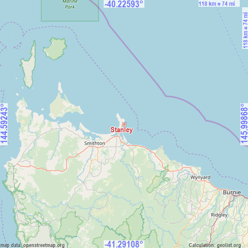
Stanley GPS coordinates[2]
40° 45' 38.304" South, 145° 17' 43.98" East
| Map corner | latitude | longitude |
|---|---|---|
| Upper-left | -40.22593°, | 144.59243° |
| Center: | -40.76064°, | 145.29555° |
| Lower-right: | -41.29108°, | 145.99868° |
| Map W x H: | 118.4×118.4 km | = 73.6×73.6mi |
| max Lat: | -10.58257° ⇑96.3% North |
| Stanley: | -40.76064° |
| min Lat: | ⇓3.7% South -43.31423° |
| min Long | Stanley | max Long |
| 113.53327° | 145.29555° | 153.61246° |
| W 38.4%⇐ | ⇒61.6% E |
Elevation
Elevation of Stanley is 18 m = 59 ft, and this is 104 m = 341 ft below average elevation for this country.
| Max E: |
1715 m = 5627 ft | 76.1% |
| Avg. | 122 m = 400 ft | |
| Stanley | 18 m = 59 ft | |
Min E: |
-2 m = -7 ft | 23.9% |
See also: Australia elevation on elevation.city.
Geographical zone
Stanley is located in South temperate zone (between Tropic of Capricorn and the Antarctic Circle). Distance of this Southern Tropic circle is 1926.2 km =1196.9 mi to North.| Distance of | km | miles | from Stanley |
|---|---|---|---|
| Equator | 4532.2 | 2816.2 | to North |
| Tropic Capricorn | 1926.2 | 1196.9 | to North |
| Antarctic Circle | 2869 | 1782.7 | to South |
| South Pole | 5474.9 | 3401.9 | to South |


Nearby cities:
15 places around Stanley: (largest is in red/bold)
• Brooklyn
62 km =38.5 mi,  123°
123°
• Burnie
60.7 km =37.7 mi, 122°
• Burnie city centre
60.9 km =37.8 mi, 122°
• Cooee
57.9 km =36 mi, 123°
• Havenview
63 km =39.1 mi, 124°
• Hillcrest
60.5 km =37.6 mi, 123°
• Montello
60.3 km =37.5 mi, 123°
• Park Grove
59.1 km =36.7 mi, 123°
• Ridgley
63.1 km =39.2 mi,  134°
134°
• Romaine
62.8 km =39 mi, 126°
• Shorewell Park
59.7 km =37.1 mi, 125°
• Smithton
17.2 km =10.7 mi,  236°
236°
• Somerset
54.7 km =34 mi, 124°
• Upper Burnie
61.4 km =38.2 mi, 124°
• Wynyard
44.3 km =27.5 mi, 125°
Sources, notices
• [Note1] Compared only with cities in Australia existing in our database
• [Src1] Map data: © OpenStreetMap contributors (CC-BY-SA)
• [Src2] Other city data from geonames.org with taken over terms of usage.
• [Src3] Geographical zone / Annual Mean Temperature by Robert A. Rohde @ Wikipedia
