Smithton geodata
Smithton (Tasmania) is a populated place; located in Australia in Australia/Hobart (GMT+11) time zone. With population of 3,815 people, there are 1861 cities with bigger population in this country. Compared to other cities in Australia, 96.3% of cities are located further ↑North; 63.8% of cities are located further →East and 81.9% of cities have higher elevation than Smithton. Note1


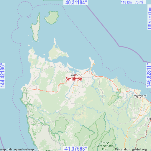
Smithton GPS coordinates[2]
40° 50' 45.132" South, 145° 7' 29.928" East
| Map corner | latitude | longitude |
|---|---|---|
| Upper-left | -40.31184°, | 144.42186° |
| Center: | -40.84587°, | 145.12498° |
| Lower-right: | -41.37563°, | 145.82811° |
| Map W x H: | 118.3×118.3 km | = 73.5×73.5mi |
| max Lat: | -10.58257° ⇑96.3% North |
| Smithton: | -40.84587° |
| min Lat: | ⇓3.7% South -43.31423° |
| min Long | Smithton | max Long |
| 113.53327° | 145.12498° | 153.61246° |
| W 36.2%⇐ | ⇒63.8% E |
Elevation
Elevation of Smithton is 14 m = 46 ft, and this is 108 m = 354 ft below average elevation for this country.
| Max E: |
1715 m = 5627 ft | 81.9% |
| Avg. | 122 m = 400 ft | |
| Smithton | 14 m = 46 ft | |
Min E: |
-2 m = -7 ft | 18.1% |
See also: Australia elevation on elevation.city.
Geographical zone
Smithton is located in South temperate zone (between Tropic of Capricorn and the Antarctic Circle). Distance of this Southern Tropic circle is 1935.7 km =1202.8 mi to North.| Distance of | km | miles | from Smithton |
|---|---|---|---|
| Equator | 4541.6 | 2822 | to North |
| Tropic Capricorn | 1935.7 | 1202.8 | to North |
| Antarctic Circle | 2859.5 | 1776.8 | to South |
| South Pole | 5465.4 | 3396 | to South |


Nearby cities:
15 places around Smithton: (largest is in red/bold)
• Brooklyn
70.3 km =43.7 mi,  110°
110°
• Burnie
69.4 km =43.1 mi, 109°
• Burnie city centre
69.6 km =43.2 mi, 109°
• Cooee
66.6 km =41.4 mi, 109°
• Havenview
71.2 km =44.2 mi, 111°
• Hillcrest
69 km =42.9 mi, 110°
• Montello
68.9 km =42.8 mi, 109°
• Park Grove
67.7 km =42.1 mi, 110°
• Ridgley
68.8 km =42.8 mi,  120°
120°
• Romaine
70.4 km =43.7 mi, 113°
• Shorewell Park
67.9 km =42.2 mi, 111°
• Somerset
63.1 km =39.2 mi, 110°
• Stanley
17.2 km =10.7 mi,  56°
56°
• Upper Burnie
69.7 km =43.3 mi, 111°
• Wynyard
53 km =32.9 mi, 107°
Sources, notices
• [Note1] Compared only with cities in Australia existing in our database
• [Src1] Map data: © OpenStreetMap contributors (CC-BY-SA)
• [Src2] Other city data from geonames.org with taken over terms of usage.
• [Src3] Geographical zone / Annual Mean Temperature by Robert A. Rohde @ Wikipedia
