Seaforth geodata
Seaforth (Queensland) is a populated place; located in Australia in Australia/Brisbane (GMT+10) time zone. With population of 901 people, there are 3970 cities with bigger population in this country. Compared to other cities in Australia, 93.7% of cities are located further ↓South; 52.6% of cities are located further ←West and 88.3% of cities have higher elevation than Seaforth. Note1


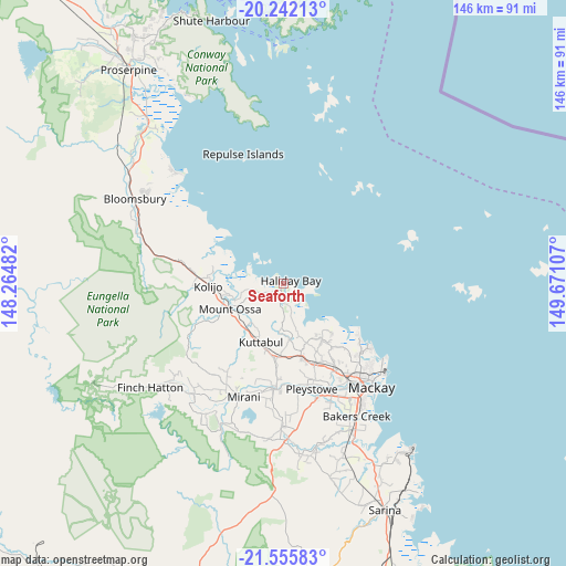
Seaforth GPS coordinates[2]
20° 54' 1.512" South, 148° 58' 4.584" East
| Map corner | latitude | longitude |
|---|---|---|
| Upper-left | -20.24213°, | 148.26482° |
| Center: | -20.90042°, | 148.96794° |
| Lower-right: | -21.55583°, | 149.67107° |
| Map W x H: | 146.1×146.1 km | = 90.8×90.8mi |
| max Lat: | -10.58257° ⇑6.3% North |
| Seaforth: | -20.90042° |
| min Lat: | ⇓93.7% South -43.31423° |
| min Long | Seaforth | max Long |
| 113.53327° | 148.96794° | 153.61246° |
| W 52.6%⇐ | ⇒47.4% E |
Elevation
Elevation of Seaforth is 10 m = 33 ft, and this is 112 m = 367 ft below average elevation for this country.
| Max E: |
1715 m = 5627 ft | 88.3% |
| Avg. | 122 m = 400 ft | |
| Seaforth | 10 m = 33 ft | |
Min E: |
-2 m = -7 ft | 11.7% |
See also: Australia elevation on elevation.city.
Geographical zone
Seaforth is located in South Torrid zone (between Equator and Tropic of Capricorn). Distance of this Southern Tropic circle is 282 km =175.2 mi to South.| Distance of | km | miles | from Seaforth |
|---|---|---|---|
| Equator | 2323.9 | 1444 | to North |
| Tropic Capricorn | 282 | 175.2 | to South |
| Antarctic Circle | 5077.3 | 3154.9 | to South |
| South Pole | 7683.2 | 4774.1 | to South |


Nearby cities:
15 places around Seaforth: (largest is in red/bold)
• Andergrove
30.2 km =18.8 mi,  132°
132°
• Beaconsfield
29.5 km =18.3 mi,  135°
135°
• Blacks Beach
28.7 km =17.8 mi, 126°
• Bucasia
24.7 km =15.3 mi, 127°
• Eimeo
26.5 km =16.5 mi, 125°
• Erakala
29.7 km =18.5 mi,  148°
148°
• Farleigh
26.8 km =16.7 mi, 148°
• Glenella
30.3 km =18.8 mi, 142°
• Habana
19 km =11.8 mi, 140°
• Hampden
18.8 km =11.7 mi,  190°
190°
• Kuttabul
16.4 km =10.2 mi,  205°
205°
• Marian
27.2 km =16.9 mi, 185°
• Rural View
27.4 km =17 mi, 131°
• Shoal Point
22.4 km =13.9 mi,  121°
121°
• The Leap
21 km =13 mi,  166°
166°
Sources, notices
• [Note1] Compared only with cities in Australia existing in our database
• [Src1] Map data: © OpenStreetMap contributors (CC-BY-SA)
• [Src2] Other city data from geonames.org with taken over terms of usage.
• [Src3] Geographical zone / Annual Mean Temperature by Robert A. Rohde @ Wikipedia
