Sancrox geodata
Sancrox (New South Wales) is a populated place; located in Australia in Australia/Sydney (GMT+11) time zone. With population of 565 people, there are 4668 cities with bigger population in this country. Compared to other cities in Australia, 69.8% of cities are located further ↓South; 86.9% of cities are located further ←West and 85% of cities have higher elevation than Sancrox. Note1


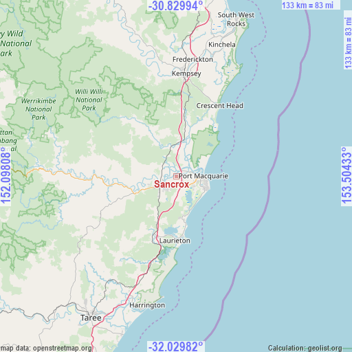
Sancrox GPS coordinates[2]
31° 25' 54.48" South, 152° 48' 4.32" East
| Map corner | latitude | longitude |
|---|---|---|
| Upper-left | -30.82994°, | 152.09808° |
| Center: | -31.4318°, | 152.8012° |
| Lower-right: | -32.02982°, | 153.50433° |
| Map W x H: | 133.4×133.4 km | = 82.9×82.9mi |
| max Lat: | -10.58257° ⇑30.2% North |
| Sancrox: | -31.4318° |
| min Lat: | ⇓69.8% South -43.31423° |
| min Long | Sancrox | max Long |
| 113.53327° | 152.8012° | 153.61246° |
| W 86.9%⇐ | ⇒13.1% E |
Elevation
Elevation of Sancrox is 12 m = 39 ft, and this is 110 m = 361 ft below average elevation for this country.
| Max E: |
1715 m = 5627 ft | 85% |
| Avg. | 122 m = 400 ft | |
| Sancrox | 12 m = 39 ft | |
Min E: |
-2 m = -7 ft | 15% |
See also: Australia elevation on elevation.city.
Geographical zone
Sancrox is located in South temperate zone (between Tropic of Capricorn and the Antarctic Circle). Distance of this Southern Tropic circle is 889 km =552.4 mi to North.| Distance of | km | miles | from Sancrox |
|---|---|---|---|
| Equator | 3494.9 | 2171.6 | to North |
| Tropic Capricorn | 889 | 552.4 | to North |
| Antarctic Circle | 3906.3 | 2427.3 | to South |
| South Pole | 6512.2 | 4046.5 | to South |


Nearby cities:
15 places around Sancrox: (largest is in red/bold)
• Beechwood
11.8 km =7.3 mi,  267°
267°
• Bonny Hills
18 km =11.2 mi,  168°
168°
• Camden Haven
23.7 km =14.7 mi,  181°
181°
• Crosslands
8.2 km =5.1 mi,  264°
264°
• Dunbogan
24.3 km =15.1 mi, 176°
• Kendall
24.2 km =15 mi,  202°
202°
• Kew
23.8 km =14.8 mi, 197°
• King Creek
8 km =5 mi,  212°
212°
• Lake Cathie
14.3 km =8.9 mi,  159°
159°
• Lakewood
22.6 km =14 mi,  190°
190°
• North Haven
22.8 km =14.2 mi, 177°
• Port Macquarie
10.2 km =6.3 mi,  89°
89°
• Telegraph Point
11.9 km =7.4 mi,  359°
359°
• Wauchope
7.7 km =4.8 mi,  247°
247°
• West Haven
22.7 km =14.1 mi, 184°
Sources, notices
• [Note1] Compared only with cities in Australia existing in our database
• [Src1] Map data: © OpenStreetMap contributors (CC-BY-SA)
• [Src2] Other city data from geonames.org with taken over terms of usage.
• [Src3] Geographical zone / Annual Mean Temperature by Robert A. Rohde @ Wikipedia
