Crosslands geodata
Crosslands (New South Wales) is a section of populated place; located in Australia in Australia/Sydney (GMT+11) time zone. With population of 578 people, there are 4627 cities with bigger population in this country. Compared to other cities in Australia, 69.8% of cities are located further ↓South; 85.9% of cities are located further ←West and 67.2% of cities have higher elevation than Crosslands. Note1


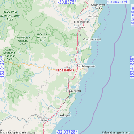
Crosslands GPS coordinates[2]
31° 26' 21.516" South, 152° 42' 55.548" East
| Map corner | latitude | longitude |
|---|---|---|
| Upper-left | -30.8375°, | 152.01231° |
| Center: | -31.43931°, | 152.71543° |
| Lower-right: | -32.03728°, | 153.41856° |
| Map W x H: | 133.4×133.4 km | = 82.9×82.9mi |
| max Lat: | -10.58257° ⇑30.2% North |
| Crosslands: | -31.43931° |
| min Lat: | ⇓69.8% South -43.31423° |
| min Long | Crosslands | max Long |
| 113.53327° | 152.71543° | 153.61246° |
| W 85.9%⇐ | ⇒14.1% E |
Elevation
Elevation of Crosslands is 25 m = 82 ft, and this is 97 m = 318 ft below average elevation for this country.
| Max E: |
1715 m = 5627 ft | 67.2% |
| Avg. | 122 m = 400 ft | |
| Crosslands | 25 m = 82 ft | |
Min E: |
-2 m = -7 ft | 32.8% |
See also: Australia elevation on elevation.city.
Geographical zone
Crosslands is located in South temperate zone (between Tropic of Capricorn and the Antarctic Circle). Distance of this Southern Tropic circle is 889.8 km =552.9 mi to North.| Distance of | km | miles | from Crosslands |
|---|---|---|---|
| Equator | 3495.7 | 2172.1 | to North |
| Tropic Capricorn | 889.8 | 552.9 | to North |
| Antarctic Circle | 3905.5 | 2426.8 | to South |
| South Pole | 6511.3 | 4045.9 | to South |


Nearby cities:
15 places around Crosslands: (largest is in red/bold)
• Beechwood
3.7 km =2.3 mi,  274°
274°
• Bonny Hills
20.5 km =12.7 mi,  145°
145°
• Camden Haven
24.1 km =15 mi,  161°
161°
• Dunbogan
25.3 km =15.7 mi, 157°
• Kendall
21.6 km =13.4 mi,  182°
182°
• Kew
21.9 km =13.6 mi, 177°
• King Creek
7.1 km =4.4 mi, 146°
• Lake Cathie
18.2 km =11.3 mi,  133°
133°
• Lakewood
21.8 km =13.5 mi,  169°
169°
• North Haven
23.8 km =14.8 mi, 157°
• Port Macquarie
18.4 km =11.4 mi,  87°
87°
• Sancrox
8.2 km =5.1 mi,  84°
84°
• Telegraph Point
15.1 km =9.4 mi,  32°
32°
• Wauchope
2.3 km =1.4 mi, 153°
• West Haven
22.8 km =14.2 mi, 163°
Sources, notices
• [Note1] Compared only with cities in Australia existing in our database
• [Src1] Map data: © OpenStreetMap contributors (CC-BY-SA)
• [Src2] Other city data from geonames.org with taken over terms of usage.
• [Src3] Geographical zone / Annual Mean Temperature by Robert A. Rohde @ Wikipedia
