Bonny Hills geodata
Bonny Hills (New South Wales) is a populated place; located in Australia in Australia/Sydney (GMT+11) time zone. With population of 3,017 people, there are 2245 cities with bigger population in this country. Compared to other cities in Australia, 69.4% of cities are located further ↓South; 87.5% of cities are located further ←West and 67.2% of cities have higher elevation than Bonny Hills. Note1


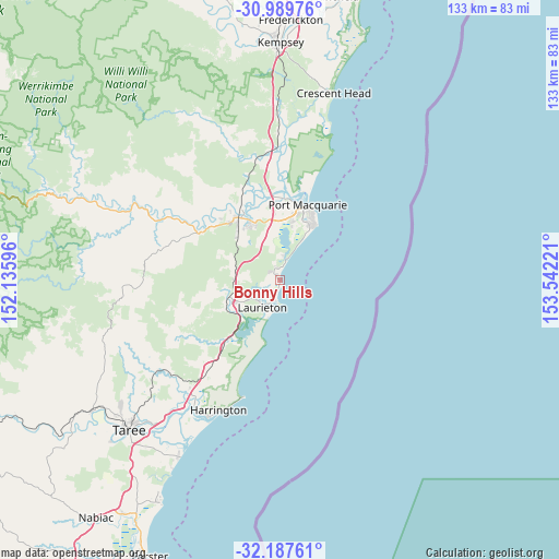
Bonny Hills GPS coordinates[2]
31° 35' 26.196" South, 152° 50' 20.688" East
| Map corner | latitude | longitude |
|---|---|---|
| Upper-left | -30.98976°, | 152.13596° |
| Center: | -31.59061°, | 152.83908° |
| Lower-right: | -32.18761°, | 153.54221° |
| Map W x H: | 133.2×133.2 km | = 82.8×82.8mi |
| max Lat: | -10.58257° ⇑30.6% North |
| Bonny Hills: | -31.59061° |
| min Lat: | ⇓69.4% South -43.31423° |
| min Long | Bonny Hills | max Long |
| 113.53327° | 152.83908° | 153.61246° |
| W 87.5%⇐ | ⇒12.5% E |
Elevation
Elevation of Bonny Hills is 25 m = 82 ft, and this is 97 m = 318 ft below average elevation for this country.
| Max E: |
1715 m = 5627 ft | 67.2% |
| Avg. | 122 m = 400 ft | |
| Bonny Hills | 25 m = 82 ft | |
Min E: |
-2 m = -7 ft | 32.8% |
See also: Australia elevation on elevation.city.
Geographical zone
Bonny Hills is located in South temperate zone (between Tropic of Capricorn and the Antarctic Circle). Distance of this Southern Tropic circle is 906.6 km =563.3 mi to North.| Distance of | km | miles | from Bonny Hills |
|---|---|---|---|
| Equator | 3512.5 | 2182.6 | to North |
| Tropic Capricorn | 906.6 | 563.3 | to North |
| Antarctic Circle | 3888.6 | 2416.3 | to South |
| South Pole | 6494.5 | 4035.5 | to South |


Nearby cities:
15 places around Bonny Hills: (largest is in red/bold)
• Beechwood
23 km =14.3 mi,  318°
318°
• Camden Haven
7.4 km =4.6 mi,  214°
214°
• Crosslands
20.5 km =12.7 mi,  325°
325°
• Dunbogan
6.9 km =4.3 mi,  197°
197°
• Kendall
13.6 km =8.5 mi,  249°
249°
• Kew
11.8 km =7.3 mi,  244°
244°
• King Creek
13.4 km =8.3 mi, 324°
• Lake Cathie
4.6 km =2.9 mi,  18°
18°
• Lakewood
8.9 km =5.5 mi, 238°
• North Haven
5.7 km =3.5 mi, 205°
• Port Macquarie
19 km =11.8 mi, 20°
• Sancrox
18 km =11.2 mi,  348°
348°
• Telegraph Point
29.8 km =18.5 mi, 352°
• Wauchope
18.2 km =11.3 mi, 324°
• West Haven
7.2 km =4.5 mi,  226°
226°
Sources, notices
• [Note1] Compared only with cities in Australia existing in our database
• [Src1] Map data: © OpenStreetMap contributors (CC-BY-SA)
• [Src2] Other city data from geonames.org with taken over terms of usage.
• [Src3] Geographical zone / Annual Mean Temperature by Robert A. Rohde @ Wikipedia
