Samford geodata
Samford (Queensland) is a section of populated place; located in Australia in Australia/Brisbane (GMT+10) time zone. With population of 656 people, there are 4421 cities with bigger population in this country. Compared to other cities in Australia, 84% of cities are located further ↓South; 88.4% of cities are located further ←West and 56.3% of cities have lower elevation than Samford. Note1


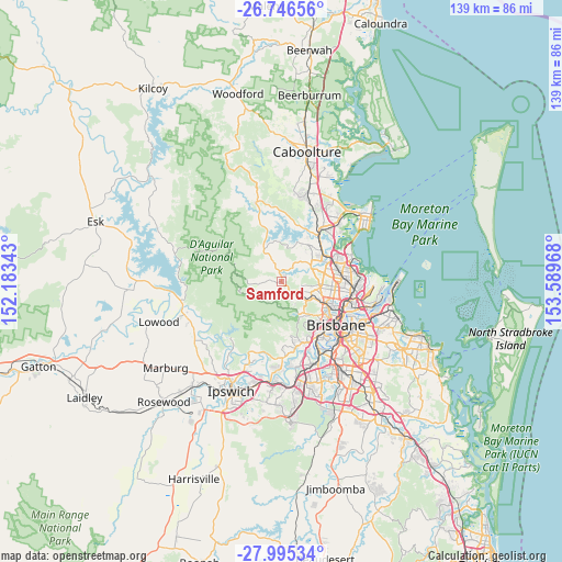
Samford GPS coordinates[2]
27° 22' 21.756" South, 152° 53' 11.58" East
| Map corner | latitude | longitude |
|---|---|---|
| Upper-left | -26.74656°, | 152.18343° |
| Center: | -27.37271°, | 152.88655° |
| Lower-right: | -27.99534°, | 153.58968° |
| Map W x H: | 138.9×138.9 km | = 86.3×86.3mi |
| max Lat: | -10.58257° ⇑16% North |
| Samford: | -27.37271° |
| min Lat: | ⇓84% South -43.31423° |
| min Long | Samford | max Long |
| 113.53327° | 152.88655° | 153.61246° |
| W 88.4%⇐ | ⇒11.6% E |
Elevation
Elevation of Samford is 56 m = 184 ft, and this is 66 m = 217 ft below average elevation for this country.
| Max E: |
1715 m = 5627 ft | 43.7% |
| Avg. | 122 m = 400 ft | |
| Samford | 56 m = 184 ft | |
Min E: |
-2 m = -7 ft | 56.3% |
See also: Australia elevation on elevation.city.
Geographical zone
Samford is located in South temperate zone (between Tropic of Capricorn and the Antarctic Circle). Distance of this Southern Tropic circle is 437.6 km =271.9 mi to North.| Distance of | km | miles | from Samford |
|---|---|---|---|
| Equator | 3043.6 | 1891.2 | to North |
| Tropic Capricorn | 437.6 | 271.9 | to North |
| Antarctic Circle | 4357.6 | 2707.7 | to South |
| South Pole | 6963.5 | 4326.9 | to South |


Nearby cities:
15 places around Samford: (largest is in red/bold)
• Albany Creek
8.4 km =5.2 mi,  75°
75°
• Arana Hills
7.6 km =4.7 mi,  111°
111°
• Bunya
5.6 km =3.5 mi,  86°
86°
• Camp Mountain
3.1 km =1.9 mi,  185°
185°
• Cedar Creek
8 km =5 mi,  303°
303°
• Clear Mountain
7.5 km =4.7 mi,  357°
357°
• Closeburn
5.5 km =3.4 mi,  336°
336°
• Draper
3 km =1.9 mi,  41°
41°
• Eatons Hill
8.1 km =5 mi,  62°
62°
• Ferny Grove
5.7 km =3.5 mi,  123°
123°
• Ferny Hills
5.6 km =3.5 mi, 117°
• Keperra
7.5 km =4.7 mi,  127°
127°
• Samford Valley
1.9 km =1.2 mi,  270°
270°
• Upper Kedron
6 km =3.7 mi,  148°
148°
• Wights Mountain
3.8 km =2.4 mi,  233°
233°
Sources, notices
• [Note1] Compared only with cities in Australia existing in our database
• [Src1] Map data: © OpenStreetMap contributors (CC-BY-SA)
• [Src2] Other city data from geonames.org with taken over terms of usage.
• [Src3] Geographical zone / Annual Mean Temperature by Robert A. Rohde @ Wikipedia
