Cedar Creek geodata
Cedar Creek (Queensland) is a section of populated place; located in Australia in Australia/Brisbane (GMT+10) time zone. With population of 728 people, there are 4283 cities with bigger population in this country. Compared to other cities in Australia, 84.4% of cities are located further ↓South; 87.2% of cities are located further ←West and 74.3% of cities have lower elevation than Cedar Creek. Note1


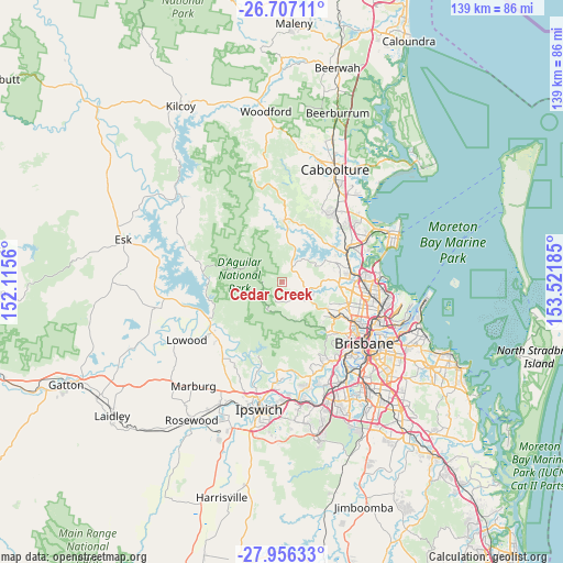
Cedar Creek GPS coordinates[2]
27° 20' 0.528" South, 152° 49' 7.392" East
| Map corner | latitude | longitude |
|---|---|---|
| Upper-left | -26.70711°, | 152.1156° |
| Center: | -27.33348°, | 152.81872° |
| Lower-right: | -27.95633°, | 153.52185° |
| Map W x H: | 138.9×138.9 km | = 86.3×86.3mi |
| max Lat: | -10.58257° ⇑15.6% North |
| Cedar Creek: | -27.33348° |
| min Lat: | ⇓84.4% South -43.31423° |
| min Long | Cedar Creek | max Long |
| 113.53327° | 152.81872° | 153.61246° |
| W 87.2%⇐ | ⇒12.8% E |
Elevation
Elevation of Cedar Creek is 125 m = 410 ft, and this is 3 m = 10 ft above average elevation for this country.
| Max E: |
1715 m = 5627 ft | 25.7% |
| Cedar Creek | 125 m 410 ft | |
| Avg. | 122 m = 400 ft | |
Min E: |
-2 m = -7 ft | 74.3% |
See also: Australia elevation on elevation.city.
Geographical zone
Cedar Creek is located in South temperate zone (between Tropic of Capricorn and the Antarctic Circle). Distance of this Southern Tropic circle is 433.3 km =269.2 mi to North.| Distance of | km | miles | from Cedar Creek |
|---|---|---|---|
| Equator | 3039.2 | 1888.5 | to North |
| Tropic Capricorn | 433.3 | 269.2 | to North |
| Antarctic Circle | 4362 | 2710.4 | to South |
| South Pole | 6967.9 | 4329.7 | to South |


Nearby cities:
15 places around Cedar Creek: (largest is in red/bold)
• Bunya
12.9 km =8 mi,  107°
107°
• Camp Mountain
9.8 km =6.1 mi,  139°
139°
• Cashmere
9.6 km =6 mi,  65°
65°
• Clear Mountain
7.1 km =4.4 mi,  63°
63°
• Closeburn
4.6 km =2.9 mi,  80°
80°
• Draper
8.9 km =5.5 mi,  103°
103°
• Ferny Hills
13.6 km =8.5 mi,  120°
120°
• Highvale
4.6 km =2.9 mi,  201°
201°
• Mount Samson
4.8 km =3 mi,  39°
39°
• Samford
8 km =5 mi, 123°
• Samford Valley
6.5 km =4 mi,  132°
132°
• Samson Vale
8 km =5 mi,  22°
22°
• Warner
13.2 km =8.2 mi, 79°
• Whiteside
12.5 km =7.8 mi,  47°
47°
• Wights Mountain
7.6 km =4.7 mi,  151°
151°
Sources, notices
• [Note1] Compared only with cities in Australia existing in our database
• [Src1] Map data: © OpenStreetMap contributors (CC-BY-SA)
• [Src2] Other city data from geonames.org with taken over terms of usage.
• [Src3] Geographical zone / Annual Mean Temperature by Robert A. Rohde @ Wikipedia
