Draper geodata
Draper (Queensland) is a section of populated place; located in Australia in Australia/Brisbane (GMT+10) time zone. With population of 668 people, there are 4387 cities with bigger population in this country. Compared to other cities in Australia, 84.2% of cities are located further ↓South; 88.6% of cities are located further ←West and 54% of cities have lower elevation than Draper. Note1


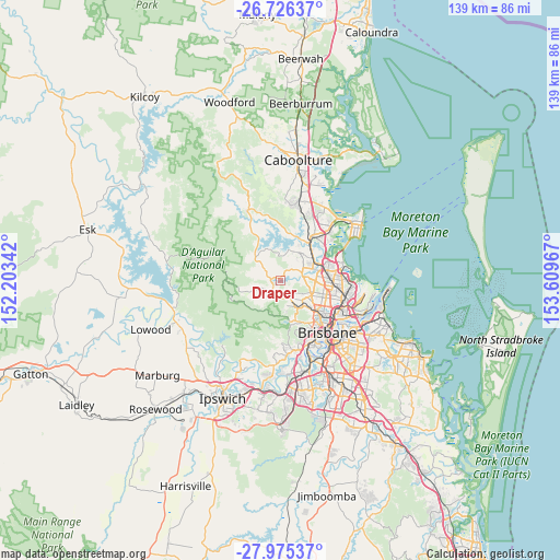
Draper GPS coordinates[2]
27° 21' 9.468" South, 152° 54' 23.544" East
| Map corner | latitude | longitude |
|---|---|---|
| Upper-left | -26.72637°, | 152.20342° |
| Center: | -27.35263°, | 152.90654° |
| Lower-right: | -27.97537°, | 153.60967° |
| Map W x H: | 138.9×138.9 km | = 86.3×86.3mi |
| max Lat: | -10.58257° ⇑15.8% North |
| Draper: | -27.35263° |
| min Lat: | ⇓84.2% South -43.31423° |
| min Long | Draper | max Long |
| 113.53327° | 152.90654° | 153.61246° |
| W 88.6%⇐ | ⇒11.4% E |
Elevation
Elevation of Draper is 51 m = 167 ft, and this is 71 m = 233 ft below average elevation for this country.
| Max E: |
1715 m = 5627 ft | 46% |
| Avg. | 122 m = 400 ft | |
| Draper | 51 m = 167 ft | |
Min E: |
-2 m = -7 ft | 54% |
See also: Australia elevation on elevation.city.
Geographical zone
Draper is located in South temperate zone (between Tropic of Capricorn and the Antarctic Circle). Distance of this Southern Tropic circle is 435.4 km =270.5 mi to North.| Distance of | km | miles | from Draper |
|---|---|---|---|
| Equator | 3041.3 | 1889.8 | to North |
| Tropic Capricorn | 435.4 | 270.5 | to North |
| Antarctic Circle | 4359.8 | 2709.1 | to South |
| South Pole | 6965.7 | 4328.3 | to South |


Nearby cities:
15 places around Draper: (largest is in red/bold)
• Albany Creek
6.1 km =3.8 mi,  91°
91°
• Arana Hills
7.2 km =4.5 mi,  134°
134°
• Bunya
4.1 km =2.5 mi,  117°
117°
• Camp Mountain
5.7 km =3.5 mi,  203°
203°
• Cashmere
6.1 km =3.8 mi,  0°
0°
• Clear Mountain
5.8 km =3.6 mi,  336°
336°
• Closeburn
5 km =3.1 mi,  304°
304°
• Eatons Hill
5.5 km =3.4 mi,  74°
74°
• Ferny Grove
6 km =3.7 mi,  152°
152°
• Ferny Hills
5.7 km =3.5 mi, 147°
• Samford
3 km =1.9 mi,  221°
221°
• Samford Valley
4.5 km =2.8 mi,  240°
240°
• Upper Kedron
7.4 km =4.6 mi,  171°
171°
• Warner
6.2 km =3.9 mi,  43°
43°
• Wights Mountain
6.8 km =4.2 mi,  228°
228°
Sources, notices
• [Note1] Compared only with cities in Australia existing in our database
• [Src1] Map data: © OpenStreetMap contributors (CC-BY-SA)
• [Src2] Other city data from geonames.org with taken over terms of usage.
• [Src3] Geographical zone / Annual Mean Temperature by Robert A. Rohde @ Wikipedia
