Bunya geodata
Bunya (Queensland) is a section of populated place; located in Australia in Australia/Brisbane (GMT+10) time zone. With population of 1,870 people, there are 2993 cities with bigger population in this country. Compared to other cities in Australia, 84.1% of cities are located further ↓South; 89.3% of cities are located further ←West and 61.7% of cities have lower elevation than Bunya. Note1


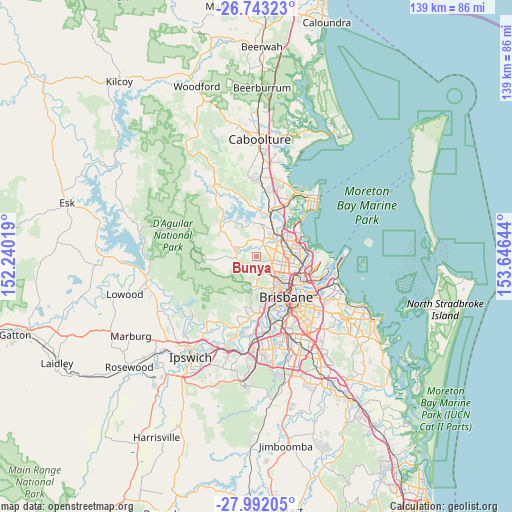
Bunya GPS coordinates[2]
27° 22' 9.84" South, 152° 56' 35.916" East
| Map corner | latitude | longitude |
|---|---|---|
| Upper-left | -26.74323°, | 152.24019° |
| Center: | -27.3694°, | 152.94331° |
| Lower-right: | -27.99205°, | 153.64644° |
| Map W x H: | 138.9×138.9 km | = 86.3×86.3mi |
| max Lat: | -10.58257° ⇑15.9% North |
| Bunya: | -27.3694° |
| min Lat: | ⇓84.1% South -43.31423° |
| min Long | Bunya | max Long |
| 113.53327° | 152.94331° | 153.61246° |
| W 89.3%⇐ | ⇒10.7% E |
Elevation
Elevation of Bunya is 69 m = 226 ft, and this is 53 m = 174 ft below average elevation for this country.
| Max E: |
1715 m = 5627 ft | 38.3% |
| Avg. | 122 m = 400 ft | |
| Bunya | 69 m = 226 ft | |
Min E: |
-2 m = -7 ft | 61.7% |
See also: Australia elevation on elevation.city.
Geographical zone
Bunya is located in South temperate zone (between Tropic of Capricorn and the Antarctic Circle). Distance of this Southern Tropic circle is 437.3 km =271.7 mi to North.| Distance of | km | miles | from Bunya |
|---|---|---|---|
| Equator | 3043.2 | 1891 | to North |
| Tropic Capricorn | 437.3 | 271.7 | to North |
| Antarctic Circle | 4358 | 2707.9 | to South |
| South Pole | 6963.9 | 4327.2 | to South |


Nearby cities:
15 places around Bunya: (largest is in red/bold)
• Albany Creek
3 km =1.9 mi,  54°
54°
• Arana Hills
3.5 km =2.2 mi,  155°
155°
• Bridgeman Downs
5.3 km =3.3 mi,  72°
72°
• Draper
4.1 km =2.5 mi,  297°
297°
• Eatons Hill
3.7 km =2.3 mi,  26°
26°
• Everton Hills
3.5 km =2.2 mi,  128°
128°
• Everton Park
6.1 km =3.8 mi, 133°
• Ferny Grove
3.6 km =2.2 mi,  193°
193°
• Ferny Hills
3 km =1.9 mi, 191°
• Keperra
4.9 km =3 mi,  175°
175°
• McDowall
5 km =3.1 mi,  107°
107°
• Mitchelton
5.7 km =3.5 mi, 156°
• Samford
5.6 km =3.5 mi,  266°
266°
• Upper Kedron
6 km =3.7 mi,  204°
204°
• Warner
6.4 km =4 mi,  5°
5°
Sources, notices
• [Note1] Compared only with cities in Australia existing in our database
• [Src1] Map data: © OpenStreetMap contributors (CC-BY-SA)
• [Src2] Other city data from geonames.org with taken over terms of usage.
• [Src3] Geographical zone / Annual Mean Temperature by Robert A. Rohde @ Wikipedia
