Robertson geodata
Robertson (New South Wales) is a populated place; located in Australia in Australia/Sydney (GMT+11) time zone. With population of 1,800 people, there are 3045 cities with bigger population in this country. Compared to other cities in Australia, 63.9% of cities are located further ↑North; 59.5% of cities are located further ←West and 98.6% of cities have lower elevation than Robertson. Note1


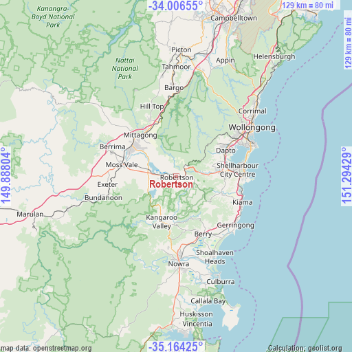
Robertson GPS coordinates[2]
34° 35' 14.712" South, 150° 35' 28.176" East
| Map corner | latitude | longitude |
|---|---|---|
| Upper-left | -34.00655°, | 149.88804° |
| Center: | -34.58742°, | 150.59116° |
| Lower-right: | -35.16425°, | 151.29429° |
| Map W x H: | 128.7×128.7 km | = 80×80mi |
| max Lat: | -10.58257° ⇑63.9% North |
| Robertson: | -34.58742° |
| min Lat: | ⇓36.1% South -43.31423° |
| min Long | Robertson | max Long |
| 113.53327° | 150.59116° | 153.61246° |
| W 59.5%⇐ | ⇒40.5% E |
Elevation
Elevation of Robertson is 730 m = 2395 ft, and this is 608 m = 1995 ft above average elevation for this country.
| Max E: |
1715 m = 5627 ft | 1.4% |
| Robertson | 730 m 2395 ft | |
| Avg. | 122 m = 400 ft | |
Min E: |
-2 m = -7 ft | 98.6% |
See also: Australia elevation on elevation.city.
Geographical zone
Robertson is located in South temperate zone (between Tropic of Capricorn and the Antarctic Circle). Distance of this Southern Tropic circle is 1239.8 km =770.4 mi to North.| Distance of | km | miles | from Robertson |
|---|---|---|---|
| Equator | 3845.8 | 2389.7 | to North |
| Tropic Capricorn | 1239.8 | 770.4 | to North |
| Antarctic Circle | 3555.4 | 2209.2 | to South |
| South Pole | 6161.3 | 3828.5 | to South |


Nearby cities:
15 places around Robertson: (largest is in red/bold)
• Albion Park
17 km =10.6 mi,  83°
83°
• Albion Park Rail
18.5 km =11.5 mi, 82°
• Avondale
16.5 km =10.3 mi,  61°
61°
• Bowral
19.9 km =12.4 mi,  308°
308°
• Burradoo
19.1 km =11.9 mi,  299°
299°
• Dapto
20.8 km =12.9 mi, 63°
• Haywards Bay
19.3 km =12 mi,  72°
72°
• Horsley
20.4 km =12.7 mi, 57°
• Jamberoo
18.1 km =11.2 mi,  111°
111°
• Kangaroo Valley
17.5 km =10.9 mi,  196°
196°
• Mittagong
20.3 km =12.6 mi,  318°
318°
• Moss Vale
20.5 km =12.7 mi,  280°
280°
• Renwick
19 km =11.8 mi, 324°
• Tullimbar
13.6 km =8.5 mi,  86°
86°
• Willow Vale
20.3 km =12.6 mi,  326°
326°
Sources, notices
• [Note1] Compared only with cities in Australia existing in our database
• [Src1] Map data: © OpenStreetMap contributors (CC-BY-SA)
• [Src2] Other city data from geonames.org with taken over terms of usage.
• [Src3] Geographical zone / Annual Mean Temperature by Robert A. Rohde @ Wikipedia
