Kangaroo Valley geodata
Kangaroo Valley (New South Wales) is a populated place; located in Australia in Australia/Sydney (GMT+11) time zone. With population of 939 people, there are 3917 cities with bigger population in this country. Compared to other cities in Australia, 65.2% of cities are located further ↑North; 59% of cities are located further ←West and 69.5% of cities have lower elevation than Kangaroo Valley. Note1


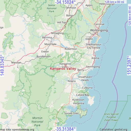
Kangaroo Valley GPS coordinates[2]
34° 44' 17.016" South, 150° 32' 11.652" East
| Map corner | latitude | longitude |
|---|---|---|
| Upper-left | -34.15824°, | 149.83345° |
| Center: | -34.73806°, | 150.53657° |
| Lower-right: | -35.31384°, | 151.2397° |
| Map W x H: | 128.5×128.5 km | = 79.8×79.8mi |
| max Lat: | -10.58257° ⇑65.2% North |
| Kangaroo Valley: | -34.73806° |
| min Lat: | ⇓34.8% South -43.31423° |
| min Long | Kangaroo Valley | max Long |
| 113.53327° | 150.53657° | 153.61246° |
| W 59%⇐ | ⇒41% E |
Elevation
Elevation of Kangaroo Valley is 100 m = 328 ft, and this is 22 m = 72 ft below average elevation for this country.
| Max E: |
1715 m = 5627 ft | 30.5% |
| Avg. | 122 m = 400 ft | |
| Kangaroo Valley | 100 m = 328 ft | |
Min E: |
-2 m = -7 ft | 69.5% |
See also: Australia elevation on elevation.city.
Geographical zone
Kangaroo Valley is located in South temperate zone (between Tropic of Capricorn and the Antarctic Circle). Distance of this Southern Tropic circle is 1256.6 km =780.8 mi to North.| Distance of | km | miles | from Kangaroo Valley |
|---|---|---|---|
| Equator | 3862.5 | 2400 | to North |
| Tropic Capricorn | 1256.6 | 780.8 | to North |
| Antarctic Circle | 3538.7 | 2198.8 | to South |
| South Pole | 6144.6 | 3818.1 | to South |


Nearby cities:
15 places around Kangaroo Valley: (largest is in red/bold)
• Berry
15 km =9.3 mi,  105°
105°
• Bomaderry
14.1 km =8.8 mi,  151°
151°
• Bundanoon
23.8 km =14.8 mi,  292°
292°
• Cambewarra Village
9.7 km =6 mi,  167°
167°
• Exeter
24.1 km =15 mi,  305°
305°
• Jamberoo
24 km =14.9 mi,  65°
65°
• North Nowra
13.8 km =8.6 mi, 165°
• Nowra
17.3 km =10.7 mi,  160°
160°
• Nowra Hill
21.4 km =13.3 mi, 171°
• Robertson
17.5 km =10.9 mi,  16°
16°
• Shoalhaven Heads
22.8 km =14.2 mi,  123°
123°
• South Nowra
19.2 km =11.9 mi, 162°
• Tapitallee
10.2 km =6.3 mi,  178°
178°
• West Nowra
17 km =10.6 mi, 165°
• Worrigee
20.1 km =12.5 mi, 153°
Sources, notices
• [Note1] Compared only with cities in Australia existing in our database
• [Src1] Map data: © OpenStreetMap contributors (CC-BY-SA)
• [Src2] Other city data from geonames.org with taken over terms of usage.
• [Src3] Geographical zone / Annual Mean Temperature by Robert A. Rohde @ Wikipedia
