Pimpama geodata
Pimpama (Queensland) is a section of populated place; located in Australia in Australia/Brisbane (GMT+10) time zone. With population of 9,396 people, there are 656 cities with bigger population in this country. Compared to other cities in Australia, 77% of cities are located further ↓South; 97.6% of cities are located further ←West and 98.8% of cities have higher elevation than Pimpama. Note1


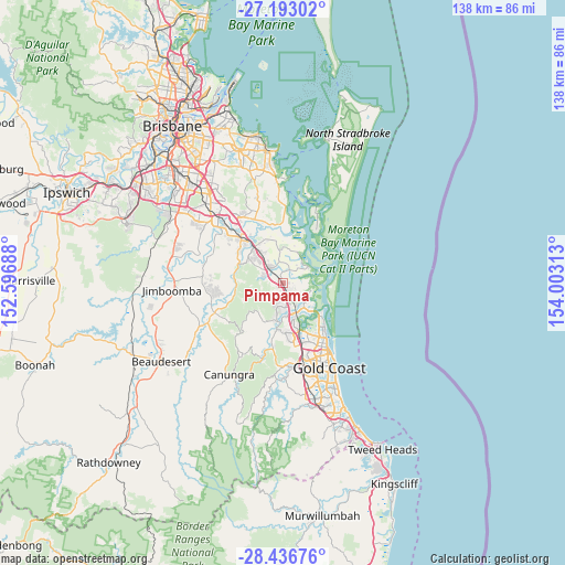
Pimpama GPS coordinates[2]
27° 49' 0.012" South, 153° 18' 0" East
| Map corner | latitude | longitude |
|---|---|---|
| Upper-left | -27.19302°, | 152.59688° |
| Center: | -27.81667°, | 153.3° |
| Lower-right: | -28.43676°, | 154.00313° |
| Map W x H: | 138.3×138.3 km | = 85.9×85.9mi |
| max Lat: | -10.58257° ⇑23% North |
| Pimpama: | -27.81667° |
| min Lat: | ⇓77% South -43.31423° |
| min Long | Pimpama | max Long |
| 113.53327° | 153.3° | 153.61246° |
| W 97.6%⇐ | ⇒2.4% E |
Elevation
Elevation of Pimpama is 3 m = 10 ft, and this is 119 m = 390 ft below average elevation for this country.
| Max E: |
1715 m = 5627 ft | 98.8% |
| Avg. | 122 m = 400 ft | |
| Pimpama | 3 m = 10 ft | |
Min E: |
-2 m = -7 ft | 1.2% |
See also: Australia elevation on elevation.city.
Geographical zone
Pimpama is located in South temperate zone (between Tropic of Capricorn and the Antarctic Circle). Distance of this Southern Tropic circle is 487 km =302.6 mi to North.| Distance of | km | miles | from Pimpama |
|---|---|---|---|
| Equator | 3092.9 | 1921.8 | to North |
| Tropic Capricorn | 487 | 302.6 | to North |
| Antarctic Circle | 4308.3 | 2677.1 | to South |
| South Pole | 6914.1 | 4296.2 | to South |


Nearby cities:
15 places around Pimpama: (largest is in red/bold)
• Bannockburn
12.3 km =7.6 mi,  300°
300°
• Cedar Creek
11 km =6.8 mi,  243°
243°
• Coombabah
12.6 km =7.8 mi,  146°
146°
• Coomera
4.8 km =3 mi,  127°
127°
• Helensvale
11.7 km =7.3 mi,  164°
164°
• Hope Island
7.8 km =4.8 mi,  139°
139°
• Jacobs Well
7.3 km =4.5 mi,  55°
55°
• Ormeau
7.8 km =4.8 mi,  313°
313°
• Ormeau Hills
4.8 km =3 mi, 297°
• Oxenford
8.3 km =5.2 mi,  171°
171°
• Paradise Point
12 km =7.5 mi, 130°
• Steiglitz
8.9 km =5.5 mi,  33°
33°
• Upper Coomera
6.8 km =4.2 mi,  191°
191°
• Willow Vale
4.8 km =3 mi,  229°
229°
• Wongawallan
9.6 km =6 mi, 226°
Sources, notices
• [Note1] Compared only with cities in Australia existing in our database
• [Src1] Map data: © OpenStreetMap contributors (CC-BY-SA)
• [Src2] Other city data from geonames.org with taken over terms of usage.
• [Src3] Geographical zone / Annual Mean Temperature by Robert A. Rohde @ Wikipedia
