Coomera geodata
Coomera (Queensland) is a populated place; located in Australia in Australia/Brisbane (GMT+10) time zone. With population of 13,165 people, there are 352 cities with bigger population in this country. Compared to other cities in Australia, 77% of cities are located further ↓South; 98% of cities are located further ←West and 65.9% of cities have higher elevation than Coomera. Note1


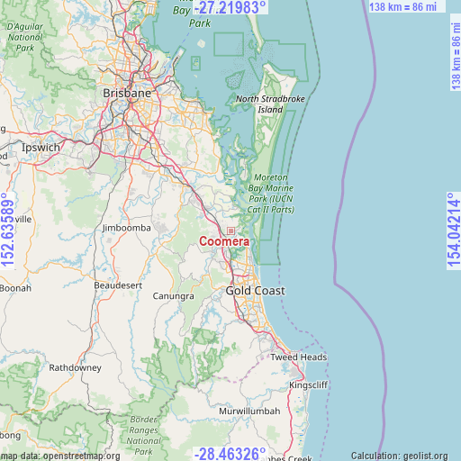
Coomera GPS coordinates[2]
27° 50' 35.988" South, 153° 20' 20.436" East
| Map corner | latitude | longitude |
|---|---|---|
| Upper-left | -27.21983°, | 152.63589° |
| Center: | -27.84333°, | 153.33901° |
| Lower-right: | -28.46326°, | 154.04214° |
| Map W x H: | 138.3×138.3 km | = 85.9×85.9mi |
| max Lat: | -10.58257° ⇑23% North |
| Coomera: | -27.84333° |
| min Lat: | ⇓77% South -43.31423° |
| min Long | Coomera | max Long |
| 113.53327° | 153.33901° | 153.61246° |
| W 98%⇐ | ⇒2% E |
Elevation
Elevation of Coomera is 26 m = 85 ft, and this is 96 m = 315 ft below average elevation for this country.
| Max E: |
1715 m = 5627 ft | 65.9% |
| Avg. | 122 m = 400 ft | |
| Coomera | 26 m = 85 ft | |
Min E: |
-2 m = -7 ft | 34.1% |
See also: Australia elevation on elevation.city.
Geographical zone
Coomera is located in South temperate zone (between Tropic of Capricorn and the Antarctic Circle). Distance of this Southern Tropic circle is 490 km =304.5 mi to North.| Distance of | km | miles | from Coomera |
|---|---|---|---|
| Equator | 3095.9 | 1923.7 | to North |
| Tropic Capricorn | 490 | 304.5 | to North |
| Antarctic Circle | 4305.3 | 2675.2 | to South |
| South Pole | 6911.2 | 4294.4 | to South |


Nearby cities:
15 places around Coomera: (largest is in red/bold)
• Arundel
10.8 km =6.7 mi,  167°
167°
• Coombabah
8.1 km =5 mi,  157°
157°
• Helensvale
8.4 km =5.2 mi,  184°
184°
• Hollywell
8.5 km =5.3 mi,  138°
138°
• Hope Island
3.3 km =2.1 mi, 157°
• Jacobs Well
7.4 km =4.6 mi,  17°
17°
• Ormeau Hills
9.6 km =6 mi,  302°
302°
• Oxenford
5.8 km =3.6 mi,  205°
205°
• Pacific Pines
11 km =6.8 mi,  192°
192°
• Paradise Point
7.2 km =4.5 mi,  132°
132°
• Pimpama
4.8 km =3 mi,  307°
307°
• Runaway Bay
9.7 km =6 mi, 143°
• Steiglitz
10.4 km =6.5 mi,  5°
5°
• Upper Coomera
6.4 km =4 mi,  234°
234°
• Willow Vale
7.5 km =4.7 mi,  268°
268°
Sources, notices
• [Note1] Compared only with cities in Australia existing in our database
• [Src1] Map data: © OpenStreetMap contributors (CC-BY-SA)
• [Src2] Other city data from geonames.org with taken over terms of usage.
• [Src3] Geographical zone / Annual Mean Temperature by Robert A. Rohde @ Wikipedia
