Pearcedale geodata
Pearcedale (Victoria) is a section of populated place; located in Australia in Australia/Melbourne (GMT+11) time zone. With population of 3,753 people, there are 1898 cities with bigger population in this country. Compared to other cities in Australia, 94.1% of cities are located further ↑North; 62.2% of cities are located further →East and 69.8% of cities have higher elevation than Pearcedale. Note1


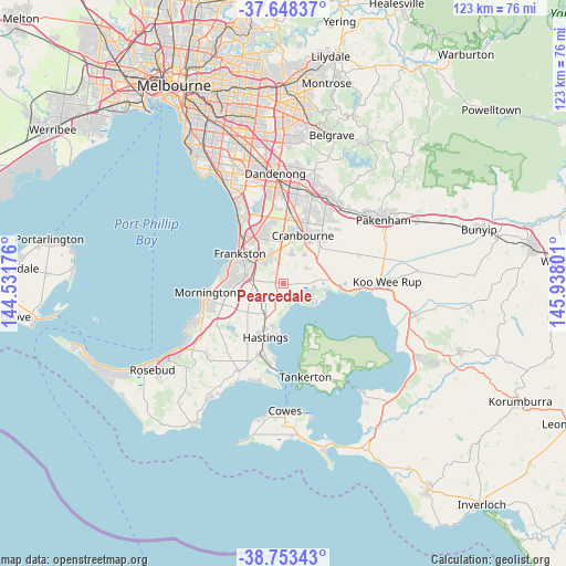
Pearcedale GPS coordinates[2]
38° 12' 10.8" South, 145° 14' 5.568" East
| Map corner | latitude | longitude |
|---|---|---|
| Upper-left | -37.64837°, | 144.53176° |
| Center: | -38.203°, | 145.23488° |
| Lower-right: | -38.75343°, | 145.93801° |
| Map W x H: | 122.9×122.9 km | = 76.4×76.4mi |
| max Lat: | -10.58257° ⇑94.1% North |
| Pearcedale: | -38.203° |
| min Lat: | ⇓5.9% South -43.31423° |
| min Long | Pearcedale | max Long |
| 113.53327° | 145.23488° | 153.61246° |
| W 37.8%⇐ | ⇒62.2% E |
Elevation
Elevation of Pearcedale is 23 m = 75 ft, and this is 99 m = 325 ft below average elevation for this country.
| Max E: |
1715 m = 5627 ft | 69.8% |
| Avg. | 122 m = 400 ft | |
| Pearcedale | 23 m = 75 ft | |
Min E: |
-2 m = -7 ft | 30.2% |
See also: Australia elevation on elevation.city.
Geographical zone
Pearcedale is located in South temperate zone (between Tropic of Capricorn and the Antarctic Circle). Distance of this Southern Tropic circle is 1641.9 km =1020.2 mi to North.| Distance of | km | miles | from Pearcedale |
|---|---|---|---|
| Equator | 4247.8 | 2639.5 | to North |
| Tropic Capricorn | 1641.9 | 1020.2 | to North |
| Antarctic Circle | 3153.4 | 1959.4 | to South |
| South Pole | 5759.3 | 3578.7 | to South |


Nearby cities:
15 places around Pearcedale: (largest is in red/bold)
• Baxter
7.4 km =4.6 mi,  272°
272°
• Blind Bight
9.1 km =5.7 mi,  97°
97°
• Botanic Ridge
7.7 km =4.8 mi,  22°
22°
• Cannons Creek
7.1 km =4.4 mi, 98°
• Cranbourne
10.8 km =6.7 mi, 23°
• Cranbourne South
7.6 km =4.7 mi,  3°
3°
• Devon Meadows
7 km =4.3 mi,  54°
54°
• Frankston South
9.5 km =5.9 mi,  295°
295°
• Junction Village
9.2 km =5.7 mi,  36°
36°
• Langwarrin
7.2 km =4.5 mi, 304°
• Langwarrin South
3.9 km =2.4 mi,  292°
292°
• Moorooduc
10.4 km =6.5 mi,  261°
261°
• Somerville
6.2 km =3.9 mi, 255°
• Tyabb
6.9 km =4.3 mi,  220°
220°
• Warneet
6.9 km =4.3 mi,  109°
109°
Sources, notices
• [Note1] Compared only with cities in Australia existing in our database
• [Src1] Map data: © OpenStreetMap contributors (CC-BY-SA)
• [Src2] Other city data from geonames.org with taken over terms of usage.
• [Src3] Geographical zone / Annual Mean Temperature by Robert A. Rohde @ Wikipedia
