Montville geodata
Montville (Queensland) is a section of populated place; located in Australia in Australia/Brisbane (GMT+10) time zone. With population of 1,071 people, there are 3735 cities with bigger population in this country. Compared to other cities in Australia, 86.7% of cities are located further ↓South; 88.3% of cities are located further ←West and 89.7% of cities have lower elevation than Montville. Note1


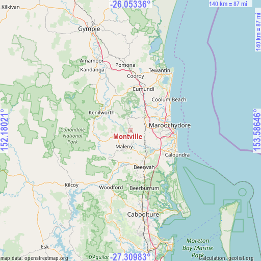
Montville GPS coordinates[2]
26° 40' 59.988" South, 152° 52' 59.988" East
| Map corner | latitude | longitude |
|---|---|---|
| Upper-left | -26.05336°, | 152.18021° |
| Center: | -26.68333°, | 152.88333° |
| Lower-right: | -27.30983°, | 153.58646° |
| Map W x H: | 139.7×139.7 km | = 86.8×86.8mi |
| max Lat: | -10.58257° ⇑13.3% North |
| Montville: | -26.68333° |
| min Lat: | ⇓86.7% South -43.31423° |
| min Long | Montville | max Long |
| 113.53327° | 152.88333° | 153.61246° |
| W 88.3%⇐ | ⇒11.7% E |
Elevation
Elevation of Montville is 361 m = 1184 ft, and this is 239 m = 784 ft above average elevation for this country.
| Max E: |
1715 m = 5627 ft | 10.3% |
| Montville | 361 m 1184 ft | |
| Avg. | 122 m = 400 ft | |
Min E: |
-2 m = -7 ft | 89.7% |
See also: Australia elevation on elevation.city.
Geographical zone
Montville is located in South temperate zone (between Tropic of Capricorn and the Antarctic Circle). Distance of this Southern Tropic circle is 361 km =224.3 mi to North.| Distance of | km | miles | from Montville |
|---|---|---|---|
| Equator | 2966.9 | 1843.5 | to North |
| Tropic Capricorn | 361 | 224.3 | to North |
| Antarctic Circle | 4434.3 | 2755.3 | to South |
| South Pole | 7040.2 | 4374.6 | to South |


Nearby cities:
15 places around Montville: (largest is in red/bold)
• Burnside
8 km =5 mi,  45°
45°
• Coes Creek
7.7 km =4.8 mi,  58°
58°
• Dulong
5.9 km =3.7 mi,  22°
22°
• Eudlo
8.7 km =5.4 mi,  126°
126°
• Flaxton
3.5 km =2.2 mi,  326°
326°
• Hunchy
2.8 km =1.7 mi,  82°
82°
• Kureelpa
8.5 km =5.3 mi,  5°
5°
• Maleny
9.2 km =5.7 mi,  201°
201°
• Mapleton
6.7 km =4.2 mi,  346°
346°
• Nambour
9.9 km =6.2 mi, 49°
• North Maleny
8 km =5 mi, 198°
• Palmwoods
7.8 km =4.8 mi,  92°
92°
• West Woombye
4.6 km =2.9 mi,  65°
65°
• Witta
6.9 km =4.3 mi,  254°
254°
• Woombye
8.9 km =5.5 mi, 73°
Sources, notices
• [Note1] Compared only with cities in Australia existing in our database
• [Src1] Map data: © OpenStreetMap contributors (CC-BY-SA)
• [Src2] Other city data from geonames.org with taken over terms of usage.
• [Src3] Geographical zone / Annual Mean Temperature by Robert A. Rohde @ Wikipedia
