Newnham geodata
Newnham (Tasmania) is a section of populated place; located in Australia in Australia/Hobart (GMT+11) time zone. With population of 6,481 people, there are 1078 cities with bigger population in this country. Compared to other cities in Australia, 97.3% of cities are located further ↑North; 52.5% of cities are located further →East and 70.9% of cities have higher elevation than Newnham. Note1


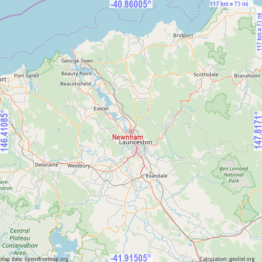
Newnham GPS coordinates[2]
41° 23' 22.884" South, 147° 6' 50.292" East
| Map corner | latitude | longitude |
|---|---|---|
| Upper-left | -40.86005°, | 146.41085° |
| Center: | -41.38969°, | 147.11397° |
| Lower-right: | -41.91505°, | 147.8171° |
| Map W x H: | 117.3×117.3 km | = 72.9×72.9mi |
| max Lat: | -10.58257° ⇑97.3% North |
| Newnham: | -41.38969° |
| min Lat: | ⇓2.7% South -43.31423° |
| min Long | Newnham | max Long |
| 113.53327° | 147.11397° | 153.61246° |
| W 47.5%⇐ | ⇒52.5% E |
Elevation
Elevation of Newnham is 22 m = 72 ft, and this is 100 m = 328 ft below average elevation for this country.
| Max E: |
1715 m = 5627 ft | 70.9% |
| Avg. | 122 m = 400 ft | |
| Newnham | 22 m = 72 ft | |
Min E: |
-2 m = -7 ft | 29.1% |
See also: Australia elevation on elevation.city.
Geographical zone
Newnham is located in South temperate zone (between Tropic of Capricorn and the Antarctic Circle). Distance of this Southern Tropic circle is 1996.2 km =1240.4 mi to North.| Distance of | km | miles | from Newnham |
|---|---|---|---|
| Equator | 4602.1 | 2859.6 | to North |
| Tropic Capricorn | 1996.2 | 1240.4 | to North |
| Antarctic Circle | 2799.1 | 1739.3 | to South |
| South Pole | 5405 | 3358.5 | to South |


Nearby cities:
15 places around Newnham: (largest is in red/bold)
• Dilston
7.8 km =4.8 mi,  328°
328°
• East Launceston
6.2 km =3.9 mi,  150°
150°
• Invermay
3.8 km =2.4 mi, 154°
• Launceston
5.7 km =3.5 mi,  162°
162°
• Launceston city centre
5.3 km =3.3 mi, 157°
• Legana
6.3 km =3.9 mi,  295°
295°
• Mayfield
1.4 km =0.9 mi,  80°
80°
• Mowbray
3.4 km =2.1 mi,  114°
114°
• Newstead
7 km =4.3 mi, 145°
• Ravenswood
6.4 km =4 mi,  117°
117°
• Riverside
6.3 km =3.9 mi,  236°
236°
• Rocherlea
3.8 km =2.4 mi,  74°
74°
• South Launceston
7.7 km =4.8 mi, 160°
• Trevallyn
5.9 km =3.7 mi,  187°
187°
• West Launceston
7 km =4.3 mi,  168°
168°
Sources, notices
• [Note1] Compared only with cities in Australia existing in our database
• [Src1] Map data: © OpenStreetMap contributors (CC-BY-SA)
• [Src2] Other city data from geonames.org with taken over terms of usage.
• [Src3] Geographical zone / Annual Mean Temperature by Robert A. Rohde @ Wikipedia
