Riverside geodata
Riverside (Tasmania) is a section of populated place; located in Australia in Australia/Hobart (GMT+11) time zone. With population of 6,303 people, there are 1128 cities with bigger population in this country. Compared to other cities in Australia, 97.4% of cities are located further ↑North; 52.8% of cities are located further →East and 76% of cities have lower elevation than Riverside. Note1


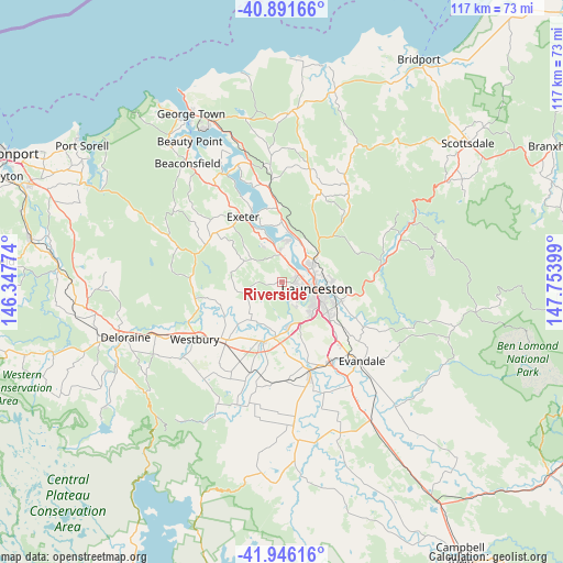
Riverside GPS coordinates[2]
41° 25' 15.78" South, 147° 3' 3.096" East
| Map corner | latitude | longitude |
|---|---|---|
| Upper-left | -40.89166°, | 146.34774° |
| Center: | -41.42105°, | 147.05086° |
| Lower-right: | -41.94616°, | 147.75399° |
| Map W x H: | 117.2×117.2 km | = 72.8×72.8mi |
| max Lat: | -10.58257° ⇑97.4% North |
| Riverside: | -41.42105° |
| min Lat: | ⇓2.6% South -43.31423° |
| min Long | Riverside | max Long |
| 113.53327° | 147.05086° | 153.61246° |
| W 47.2%⇐ | ⇒52.8% E |
Elevation
Elevation of Riverside is 139 m = 456 ft, and this is 17 m = 56 ft above average elevation for this country.
| Max E: |
1715 m = 5627 ft | 24% |
| Riverside | 139 m 456 ft | |
| Avg. | 122 m = 400 ft | |
Min E: |
-2 m = -7 ft | 76% |
See also: Australia elevation on elevation.city.
Geographical zone
Riverside is located in South temperate zone (between Tropic of Capricorn and the Antarctic Circle). Distance of this Southern Tropic circle is 1999.7 km =1242.6 mi to North.| Distance of | km | miles | from Riverside |
|---|---|---|---|
| Equator | 4605.6 | 2861.8 | to North |
| Tropic Capricorn | 1999.7 | 1242.6 | to North |
| Antarctic Circle | 2795.6 | 1737.1 | to South |
| South Pole | 5401.5 | 3356.3 | to South |


Nearby cities:
15 places around Riverside: (largest is in red/bold)
• Blackstone Heights
5.1 km =3.2 mi,  147°
147°
• East Launceston
8.6 km =5.3 mi,  103°
103°
• Grindelwald
8.6 km =5.3 mi,  333°
333°
• Invermay
6.9 km =4.3 mi,  89°
89°
• Launceston
7.3 km =4.5 mi,  105°
105°
• Launceston city centre
7.4 km =4.6 mi, 100°
• Legana
6.2 km =3.9 mi,  356°
356°
• Mayfield
7.6 km =4.7 mi,  60°
60°
• Mowbray
8.6 km =5.3 mi,  76°
76°
• Newnham
6.3 km =3.9 mi, 56°
• Prospect Vale
8 km =5 mi, 146°
• South Launceston
8.8 km =5.5 mi,  115°
115°
• Summerhill
8.2 km =5.1 mi,  128°
128°
• Trevallyn
5.1 km =3.2 mi, 117°
• West Launceston
7.5 km =4.7 mi, 116°
Sources, notices
• [Note1] Compared only with cities in Australia existing in our database
• [Src1] Map data: © OpenStreetMap contributors (CC-BY-SA)
• [Src2] Other city data from geonames.org with taken over terms of usage.
• [Src3] Geographical zone / Annual Mean Temperature by Robert A. Rohde @ Wikipedia
