Ashgrove geodata
Ashgrove (Queensland) is a section of populated place; located in Australia in Australia/Brisbane (GMT+10) time zone. With population of 12,726 people, there are 369 cities with bigger population in this country. Compared to other cities in Australia, 83.1% of cities are located further ↓South; 90.8% of cities are located further ←West and 56.9% of cities have higher elevation than Ashgrove. Note1


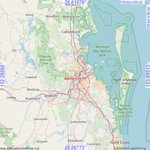
Ashgrove GPS coordinates[2]
27° 26' 43.872" South, 152° 59' 31.2" East
| Map corner | latitude | longitude |
|---|---|---|
| Upper-left | -26.81978°, | 152.28888° |
| Center: | -27.44552°, | 152.992° |
| Lower-right: | -28.06773°, | 153.69513° |
| Map W x H: | 138.8×138.8 km | = 86.2×86.2mi |
| max Lat: | -10.58257° ⇑16.9% North |
| Ashgrove: | -27.44552° |
| min Lat: | ⇓83.1% South -43.31423° |
| min Long | Ashgrove | max Long |
| 113.53327° | 152.992° | 153.61246° |
| W 90.8%⇐ | ⇒9.2% E |
Elevation
Elevation of Ashgrove is 36 m = 118 ft, and this is 86 m = 282 ft below average elevation for this country.
| Max E: |
1715 m = 5627 ft | 56.9% |
| Avg. | 122 m = 400 ft | |
| Ashgrove | 36 m = 118 ft | |
Min E: |
-2 m = -7 ft | 43.1% |
See also: Australia elevation on elevation.city.
Geographical zone
Ashgrove is located in South temperate zone (between Tropic of Capricorn and the Antarctic Circle). Distance of this Southern Tropic circle is 445.7 km =276.9 mi to North.| Distance of | km | miles | from Ashgrove |
|---|---|---|---|
| Equator | 3051.7 | 1896.2 | to North |
| Tropic Capricorn | 445.7 | 276.9 | to North |
| Antarctic Circle | 4349.5 | 2702.7 | to South |
| South Pole | 6955.4 | 4321.9 | to South |


Nearby cities:
15 places around Ashgrove: (largest is in red/bold)
• Alderley
2.4 km =1.5 mi,  21°
21°
• Auchenflower
3.2 km =2 mi,  179°
179°
• Bardon
2.1 km =1.3 mi,  216°
216°
• Enoggera
2.6 km =1.6 mi,  318°
318°
• Gaythorne
3.3 km =2.1 mi,  345°
345°
• Grange
3.4 km =2.1 mi,  41°
41°
• Herston
2.6 km =1.6 mi,  87°
87°
• Kelvin Grove
2.1 km =1.3 mi,  98°
98°
• Milton
3 km =1.9 mi,  158°
158°
• Newmarket
1.9 km =1.2 mi,  54°
54°
• Paddington
1.6 km =1 mi,  168°
168°
• Petrie Terrace
2.8 km =1.7 mi,  132°
132°
• Red Hill
1.3 km =0.8 mi, 127°
• Spring Hill
3.5 km =2.2 mi,  119°
119°
• Wilston
3.1 km =1.9 mi,  60°
60°
Sources, notices
• [Note1] Compared only with cities in Australia existing in our database
• [Src1] Map data: © OpenStreetMap contributors (CC-BY-SA)
• [Src2] Other city data from geonames.org with taken over terms of usage.
• [Src3] Geographical zone / Annual Mean Temperature by Robert A. Rohde @ Wikipedia
