Murphys Creek geodata
Murphys Creek (Queensland) is a populated place; located in Australia in Australia/Brisbane (GMT+10) time zone. With population of 617 people, there are 4522 cities with bigger population in this country. Compared to other cities in Australia, 82.7% of cities are located further ↓South; 82.9% of cities are located further ←West and 85.5% of cities have lower elevation than Murphys Creek. Note1


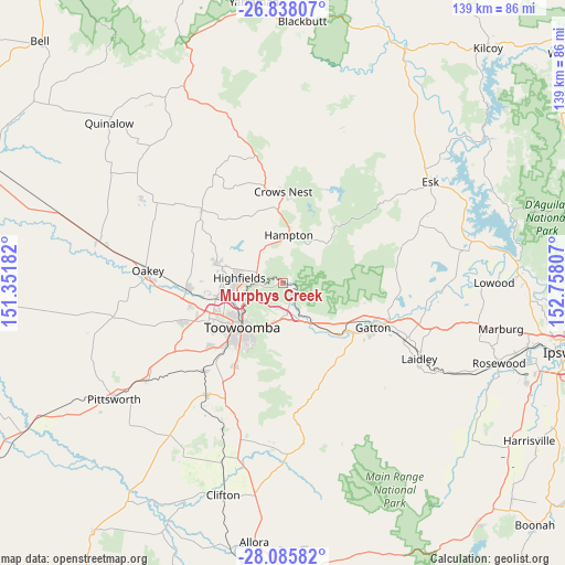
Murphys Creek GPS coordinates[2]
27° 27' 49.356" South, 152° 3' 17.784" East
| Map corner | latitude | longitude |
|---|---|---|
| Upper-left | -26.83807°, | 151.35182° |
| Center: | -27.46371°, | 152.05494° |
| Lower-right: | -28.08582°, | 152.75807° |
| Map W x H: | 138.7×138.7 km | = 86.2×86.2mi |
| max Lat: | -10.58257° ⇑17.3% North |
| Murphys Creek: | -27.46371° |
| min Lat: | ⇓82.7% South -43.31423° |
| min Long | Murphys Creek | max Long |
| 113.53327° | 152.05494° | 153.61246° |
| W 82.9%⇐ | ⇒17.1% E |
Elevation
Elevation of Murphys Creek is 255 m = 837 ft, and this is 133 m = 436 ft above average elevation for this country.
| Max E: |
1715 m = 5627 ft | 14.5% |
| Murphys Creek | 255 m 837 ft | |
| Avg. | 122 m = 400 ft | |
Min E: |
-2 m = -7 ft | 85.5% |
See also: Australia elevation on elevation.city.
Geographical zone
Murphys Creek is located in South temperate zone (between Tropic of Capricorn and the Antarctic Circle). Distance of this Southern Tropic circle is 447.8 km =278.2 mi to North.| Distance of | km | miles | from Murphys Creek |
|---|---|---|---|
| Equator | 3053.7 | 1897.5 | to North |
| Tropic Capricorn | 447.8 | 278.2 | to North |
| Antarctic Circle | 4347.5 | 2701.4 | to South |
| South Pole | 6953.4 | 4320.6 | to South |


Nearby cities:
15 places around Murphys Creek: (largest is in red/bold)
• Blue Mountain Heights
10.8 km =6.7 mi,  244°
244°
• Cabarlah
6.4 km =4 mi,  301°
301°
• Cranley
14.2 km =8.8 mi,  246°
246°
• East Toowoomba
14.3 km =8.9 mi,  213°
213°
• Harlaxton
11.6 km =7.2 mi,  228°
228°
• Helidon
12.1 km =7.5 mi,  145°
145°
• Highfields
10 km =6.2 mi,  270°
270°
• Kleinton
10.9 km =6.8 mi,  288°
288°
• Mount Lofty
12.3 km =7.6 mi,  221°
221°
• North Toowoomba
12.9 km =8 mi, 225°
• Prince Henry Heights
11.6 km =7.2 mi, 213°
• Rockville
14.1 km =8.8 mi, 235°
• Toowoomba
14.7 km =9.1 mi, 222°
• Wilsonton Heights
15 km =9.3 mi, 239°
• Withcott
10.5 km =6.5 mi,  196°
196°
Sources, notices
• [Note1] Compared only with cities in Australia existing in our database
• [Src1] Map data: © OpenStreetMap contributors (CC-BY-SA)
• [Src2] Other city data from geonames.org with taken over terms of usage.
• [Src3] Geographical zone / Annual Mean Temperature by Robert A. Rohde @ Wikipedia
