Moorabbin geodata
Moorabbin (Victoria) is a section of populated place; located in Australia in Australia/Melbourne (GMT+11) time zone. With population of 5,824 people, there are 1249 cities with bigger population in this country. Compared to other cities in Australia, 91.1% of cities are located further ↑North; 65.1% of cities are located further →East and 60% of cities have higher elevation than Moorabbin. Note1


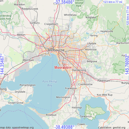
Moorabbin GPS coordinates[2]
37° 56' 29.256" South, 145° 3' 28.044" East
| Map corner | latitude | longitude |
|---|---|---|
| Upper-left | -37.38486°, | 144.35467° |
| Center: | -37.94146°, | 145.05779° |
| Lower-right: | -38.49388°, | 145.76092° |
| Map W x H: | 123.3×123.3 km | = 76.6×76.6mi |
| max Lat: | -10.58257° ⇑91.1% North |
| Moorabbin: | -37.94146° |
| min Lat: | ⇓8.9% South -43.31423° |
| min Long | Moorabbin | max Long |
| 113.53327° | 145.05779° | 153.61246° |
| W 34.9%⇐ | ⇒65.1% E |
Elevation
Elevation of Moorabbin is 32 m = 105 ft, and this is 90 m = 295 ft below average elevation for this country.
| Max E: |
1715 m = 5627 ft | 60% |
| Avg. | 122 m = 400 ft | |
| Moorabbin | 32 m = 105 ft | |
Min E: |
-2 m = -7 ft | 40% |
See also: Australia elevation on elevation.city.
Geographical zone
Moorabbin is located in South temperate zone (between Tropic of Capricorn and the Antarctic Circle). Distance of this Southern Tropic circle is 1612.8 km =1002.1 mi to North.| Distance of | km | miles | from Moorabbin |
|---|---|---|---|
| Equator | 4218.7 | 2621.4 | to North |
| Tropic Capricorn | 1612.8 | 1002.1 | to North |
| Antarctic Circle | 3182.5 | 1977.5 | to South |
| South Pole | 5788.4 | 3596.7 | to South |


Nearby cities:
15 places around Moorabbin: (largest is in red/bold)
• Bentleigh
3.3 km =2.1 mi,  323°
323°
• Bentleigh East
2.5 km =1.6 mi,  350°
350°
• Black Rock
5.1 km =3.2 mi,  225°
225°
• Cheltenham
3.2 km =2 mi,  195°
195°
• Clarinda
3.9 km =2.4 mi,  88°
88°
• Hampton East
2.6 km =1.6 mi,  281°
281°
• Heatherton
4.6 km =2.9 mi,  127°
127°
• Highett
1.2 km =0.7 mi,  215°
215°
• Hughesdale
5.1 km =3.2 mi,  25°
25°
• Kooyong
1.2 km =0.7 mi, 215°
• McKinnon
2.8 km =1.7 mi, 346°
• Mentone
4.7 km =2.9 mi,  170°
170°
• Murrumbeena
4.7 km =2.9 mi,  9°
9°
• Oakleigh South
3.5 km =2.2 mi,  56°
56°
• Sandringham
4.2 km =2.6 mi,  253°
253°
Sources, notices
• [Note1] Compared only with cities in Australia existing in our database
• [Src1] Map data: © OpenStreetMap contributors (CC-BY-SA)
• [Src2] Other city data from geonames.org with taken over terms of usage.
• [Src3] Geographical zone / Annual Mean Temperature by Robert A. Rohde @ Wikipedia
