Bentleigh East geodata
Bentleigh East (Victoria) is a section of populated place; located in Australia in Australia/Melbourne (GMT+11) time zone. With population of 27,368 people, there are 82 cities with bigger population in this country. Compared to other cities in Australia, 90.9% of cities are located further ↑North; 65.2% of cities are located further →East and 51.1% of cities have lower elevation than Bentleigh East. Note1


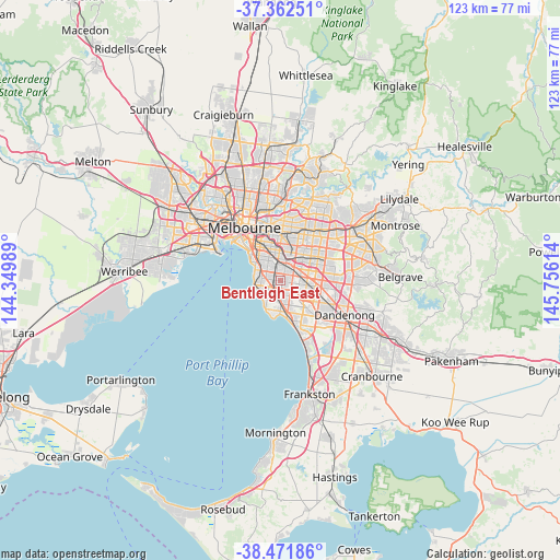
Bentleigh East GPS coordinates[2]
37° 55' 9.408" South, 145° 3' 10.836" East
| Map corner | latitude | longitude |
|---|---|---|
| Upper-left | -37.36251°, | 144.34989° |
| Center: | -37.91928°, | 145.05301° |
| Lower-right: | -38.47186°, | 145.75614° |
| Map W x H: | 123.3×123.3 km | = 76.6×76.6mi |
| max Lat: | -10.58257° ⇑90.9% North |
| Bentleigh East: | -37.91928° |
| min Lat: | ⇓9.1% South -43.31423° |
| min Long | Bentleigh East | max Long |
| 113.53327° | 145.05301° | 153.61246° |
| W 34.8%⇐ | ⇒65.2% E |
Elevation
Elevation of Bentleigh East is 47 m = 154 ft, and this is 75 m = 246 ft below average elevation for this country.
| Max E: |
1715 m = 5627 ft | 48.9% |
| Avg. | 122 m = 400 ft | |
| Bentleigh East | 47 m = 154 ft | |
Min E: |
-2 m = -7 ft | 51.1% |
See also: Australia elevation on elevation.city.
Geographical zone
Bentleigh East is located in South temperate zone (between Tropic of Capricorn and the Antarctic Circle). Distance of this Southern Tropic circle is 1610.3 km =1000.6 mi to North.| Distance of | km | miles | from Bentleigh East |
|---|---|---|---|
| Equator | 4216.2 | 2619.8 | to North |
| Tropic Capricorn | 1610.3 | 1000.6 | to North |
| Antarctic Circle | 3184.9 | 1979 | to South |
| South Pole | 5790.8 | 3598.2 | to South |


Nearby cities:
15 places around Bentleigh East: (largest is in red/bold)
• Bentleigh
1.5 km =0.9 mi,  275°
275°
• Brighton East
3.7 km =2.3 mi,  301°
301°
• Carnegie
2.9 km =1.8 mi,  4°
4°
• Caulfield South
3.5 km =2.2 mi,  317°
317°
• Glen Huntly
3.2 km =2 mi,  341°
341°
• Hampton East
2.9 km =1.8 mi,  227°
227°
• Highett
3.4 km =2.1 mi,  184°
184°
• Hughesdale
3.4 km =2.1 mi,  51°
51°
• Kooyong
3.4 km =2.1 mi, 184°
• McKinnon
0.4 km =0.2 mi, 317°
• Moorabbin
2.5 km =1.6 mi,  170°
170°
• Murrumbeena
2.5 km =1.6 mi,  29°
29°
• Oakleigh
3.9 km =2.4 mi, 52°
• Oakleigh South
3.4 km =2.1 mi,  99°
99°
• Ormond
2.8 km =1.7 mi, 321°
Sources, notices
• [Note1] Compared only with cities in Australia existing in our database
• [Src1] Map data: © OpenStreetMap contributors (CC-BY-SA)
• [Src2] Other city data from geonames.org with taken over terms of usage.
• [Src3] Geographical zone / Annual Mean Temperature by Robert A. Rohde @ Wikipedia
