Karalee geodata
Karalee (Queensland) is a section of populated place; located in Australia in Australia/Brisbane (GMT+10) time zone. With population of 4,273 people, there are 1693 cities with bigger population in this country. Compared to other cities in Australia, 80.4% of cities are located further ↓South; 87.3% of cities are located further ←West and 60% of cities have higher elevation than Karalee. Note1


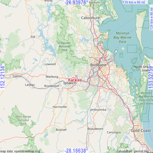
Karalee GPS coordinates[2]
27° 33' 53.46" South, 152° 49' 28.056" East
| Map corner | latitude | longitude |
|---|---|---|
| Upper-left | -26.93978°, | 152.12134° |
| Center: | -27.56485°, | 152.82446° |
| Lower-right: | -28.18638°, | 153.52759° |
| Map W x H: | 138.6×138.6 km | = 86.1×86.1mi |
| max Lat: | -10.58257° ⇑19.6% North |
| Karalee: | -27.56485° |
| min Lat: | ⇓80.4% South -43.31423° |
| min Long | Karalee | max Long |
| 113.53327° | 152.82446° | 153.61246° |
| W 87.3%⇐ | ⇒12.7% E |
Elevation
Elevation of Karalee is 32 m = 105 ft, and this is 90 m = 295 ft below average elevation for this country.
| Max E: |
1715 m = 5627 ft | 60% |
| Avg. | 122 m = 400 ft | |
| Karalee | 32 m = 105 ft | |
Min E: |
-2 m = -7 ft | 40% |
See also: Australia elevation on elevation.city.
Geographical zone
Karalee is located in South temperate zone (between Tropic of Capricorn and the Antarctic Circle). Distance of this Southern Tropic circle is 459 km =285.2 mi to North.| Distance of | km | miles | from Karalee |
|---|---|---|---|
| Equator | 3064.9 | 1904.4 | to North |
| Tropic Capricorn | 459 | 285.2 | to North |
| Antarctic Circle | 4336.3 | 2694.5 | to South |
| South Pole | 6942.1 | 4313.6 | to South |


Nearby cities:
15 places around Karalee: (largest is in red/bold)
• Anstead
4.8 km =3 mi,  50°
50°
• Barellan Point
2.1 km =1.3 mi,  112°
112°
• Bellbowrie
5.8 km =3.6 mi,  83°
83°
• Booval
6.4 km =4 mi,  212°
212°
• Bundamba
5.1 km =3.2 mi,  194°
194°
• Chuwar
4.5 km =2.8 mi,  268°
268°
• Collingwood Park
6.4 km =4 mi,  146°
146°
• Dinmore
4 km =2.5 mi,  167°
167°
• Karana Downs
2.5 km =1.6 mi,  316°
316°
• Moggill
4.6 km =2.9 mi,  116°
116°
• Moores Pocket
5.9 km =3.7 mi,  231°
231°
• Mount Crosby
3.4 km =2.1 mi,  326°
326°
• North Booval
5.2 km =3.2 mi, 213°
• Redbank
5.7 km =3.5 mi,  133°
133°
• Riverview
4.6 km =2.9 mi, 147°
Sources, notices
• [Note1] Compared only with cities in Australia existing in our database
• [Src1] Map data: © OpenStreetMap contributors (CC-BY-SA)
• [Src2] Other city data from geonames.org with taken over terms of usage.
• [Src3] Geographical zone / Annual Mean Temperature by Robert A. Rohde @ Wikipedia
