Douglas Park geodata
Douglas Park (New South Wales) is a populated place; located in Australia in Australia/Sydney (GMT+11) time zone. With population of 1,345 people, there are 3424 cities with bigger population in this country. Compared to other cities in Australia, 61.2% of cities are located further ↑North; 61% of cities are located further ←West and 73.4% of cities have lower elevation than Douglas Park. Note1


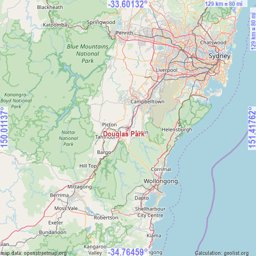
Douglas Park GPS coordinates[2]
34° 11' 5.856" South, 150° 42' 52.164" East
| Map corner | latitude | longitude |
|---|---|---|
| Upper-left | -33.60132°, | 150.01137° |
| Center: | -34.18496°, | 150.71449° |
| Lower-right: | -34.76459°, | 151.41762° |
| Map W x H: | 129.3×129.3 km | = 80.3×80.3mi |
| max Lat: | -10.58257° ⇑61.2% North |
| Douglas Park: | -34.18496° |
| min Lat: | ⇓38.8% South -43.31423° |
| min Long | Douglas Park | max Long |
| 113.53327° | 150.71449° | 153.61246° |
| W 61%⇐ | ⇒39% E |
Elevation
Elevation of Douglas Park is 119 m = 390 ft, and this is 3 m = 10 ft below average elevation for this country.
| Max E: |
1715 m = 5627 ft | 26.6% |
| Avg. | 122 m = 400 ft | |
| Douglas Park | 119 m = 390 ft | |
Min E: |
-2 m = -7 ft | 73.4% |
See also: Australia elevation on elevation.city.
Geographical zone
Douglas Park is located in South temperate zone (between Tropic of Capricorn and the Antarctic Circle). Distance of this Southern Tropic circle is 1195.1 km =742.6 mi to North.| Distance of | km | miles | from Douglas Park |
|---|---|---|---|
| Equator | 3801 | 2361.8 | to North |
| Tropic Capricorn | 1195.1 | 742.6 | to North |
| Antarctic Circle | 3600.2 | 2237.1 | to South |
| South Pole | 6206.1 | 3856.3 | to South |


Nearby cities:
15 places around Douglas Park: (largest is in red/bold)
• Ambarvale
13 km =8.1 mi,  35°
35°
• Appin
6.9 km =4.3 mi,  107°
107°
• Camden South
11.5 km =7.1 mi,  350°
350°
• Glen Alpine
12.8 km =8 mi,  30°
30°
• Menangle
6.8 km =4.2 mi,  18°
18°
• Pheasants Nest
10.8 km =6.7 mi,  223°
223°
• Picton
9.6 km =6 mi,  280°
280°
• Razorback
6.7 km =4.2 mi,  302°
302°
• Rosemeadow
11.5 km =7.1 mi, 38°
• Spring Farm
13 km =8.1 mi,  358°
358°
• St Helens Park
12.8 km =8 mi,  45°
45°
• Tahmoor
11.8 km =7.3 mi,  249°
249°
• Thirlmere
13.7 km =8.5 mi,  260°
260°
• Wedderburn
11 km =6.8 mi,  58°
58°
• Wilton
6.4 km =4 mi,  194°
194°
Sources, notices
• [Note1] Compared only with cities in Australia existing in our database
• [Src1] Map data: © OpenStreetMap contributors (CC-BY-SA)
• [Src2] Other city data from geonames.org with taken over terms of usage.
• [Src3] Geographical zone / Annual Mean Temperature by Robert A. Rohde @ Wikipedia
