Razorback geodata
Razorback (New South Wales) is a section of populated place; located in Australia in Australia/Sydney (GMT+11) time zone. With population of 1,089 people, there are 3713 cities with bigger population in this country. Compared to other cities in Australia, 60.9% of cities are located further ↑North; 60.3% of cities are located further ←West and 86.6% of cities have lower elevation than Razorback. Note1


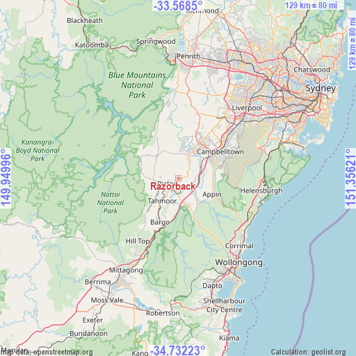
Razorback GPS coordinates[2]
34° 9' 8.532" South, 150° 39' 11.088" East
| Map corner | latitude | longitude |
|---|---|---|
| Upper-left | -33.5685°, | 149.94996° |
| Center: | -34.15237°, | 150.65308° |
| Lower-right: | -34.73223°, | 151.35621° |
| Map W x H: | 129.4×129.4 km | = 80.4×80.4mi |
| max Lat: | -10.58257° ⇑60.9% North |
| Razorback: | -34.15237° |
| min Lat: | ⇓39.1% South -43.31423° |
| min Long | Razorback | max Long |
| 113.53327° | 150.65308° | 153.61246° |
| W 60.3%⇐ | ⇒39.7% E |
Elevation
Elevation of Razorback is 278 m = 912 ft, and this is 156 m = 512 ft above average elevation for this country.
| Max E: |
1715 m = 5627 ft | 13.4% |
| Razorback | 278 m 912 ft | |
| Avg. | 122 m = 400 ft | |
Min E: |
-2 m = -7 ft | 86.6% |
See also: Australia elevation on elevation.city.
Geographical zone
Razorback is located in South temperate zone (between Tropic of Capricorn and the Antarctic Circle). Distance of this Southern Tropic circle is 1191.5 km =740.4 mi to North.| Distance of | km | miles | from Razorback |
|---|---|---|---|
| Equator | 3797.4 | 2359.6 | to North |
| Tropic Capricorn | 1191.5 | 740.4 | to North |
| Antarctic Circle | 3603.8 | 2239.3 | to South |
| South Pole | 6209.7 | 3858.5 | to South |


Nearby cities:
15 places around Razorback: (largest is in red/bold)
• Belimbla Park
12.9 km =8 mi,  306°
306°
• Camden
11.6 km =7.2 mi,  19°
19°
• Camden South
8.6 km =5.3 mi,  26°
26°
• Douglas Park
6.7 km =4.2 mi,  122°
122°
• Elderslie
12.2 km =7.6 mi, 27°
• Grasmere
11 km =6.8 mi,  6°
6°
• Menangle
8.4 km =5.2 mi,  70°
70°
• Mount Hunter
9.1 km =5.7 mi,  351°
351°
• Pheasants Nest
11.6 km =7.2 mi,  188°
188°
• Picton
4.3 km =2.7 mi,  242°
242°
• Spring Farm
10.8 km =6.7 mi, 30°
• Tahmoor
9.5 km =5.9 mi,  214°
214°
• The Oaks
11.1 km =6.9 mi,  316°
316°
• Thirlmere
9.8 km =6.1 mi,  233°
233°
• Wilton
10.6 km =6.6 mi,  157°
157°
Sources, notices
• [Note1] Compared only with cities in Australia existing in our database
• [Src1] Map data: © OpenStreetMap contributors (CC-BY-SA)
• [Src2] Other city data from geonames.org with taken over terms of usage.
• [Src3] Geographical zone / Annual Mean Temperature by Robert A. Rohde @ Wikipedia
