Marburg geodata
Marburg (Queensland) is a section of populated place; located in Australia in Australia/Brisbane (GMT+10) time zone. With population of 885 people, there are 3996 cities with bigger population in this country. Compared to other cities in Australia, 80.3% of cities are located further ↓South; 85.1% of cities are located further ←West and 64.6% of cities have lower elevation than Marburg. Note1


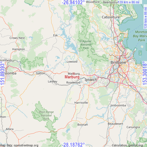
Marburg GPS coordinates[2]
27° 33' 57.924" South, 152° 35' 49.38" East
| Map corner | latitude | longitude |
|---|---|---|
| Upper-left | -26.94102°, | 151.89393° |
| Center: | -27.56609°, | 152.59705° |
| Lower-right: | -28.18762°, | 153.30018° |
| Map W x H: | 138.6×138.6 km | = 86.1×86.1mi |
| max Lat: | -10.58257° ⇑19.7% North |
| Marburg: | -27.56609° |
| min Lat: | ⇓80.3% South -43.31423° |
| min Long | Marburg | max Long |
| 113.53327° | 152.59705° | 153.61246° |
| W 85.1%⇐ | ⇒14.9% E |
Elevation
Elevation of Marburg is 79 m = 259 ft, and this is 43 m = 141 ft below average elevation for this country.
| Max E: |
1715 m = 5627 ft | 35.4% |
| Avg. | 122 m = 400 ft | |
| Marburg | 79 m = 259 ft | |
Min E: |
-2 m = -7 ft | 64.6% |
See also: Australia elevation on elevation.city.
Geographical zone
Marburg is located in South temperate zone (between Tropic of Capricorn and the Antarctic Circle). Distance of this Southern Tropic circle is 459.1 km =285.3 mi to North.| Distance of | km | miles | from Marburg |
|---|---|---|---|
| Equator | 3065.1 | 1904.6 | to North |
| Tropic Capricorn | 459.1 | 285.3 | to North |
| Antarctic Circle | 4336.1 | 2694.3 | to South |
| South Pole | 6942 | 4313.6 | to South |


Nearby cities:
15 places around Marburg: (largest is in red/bold)
• Brassall
15.2 km =9.4 mi,  103°
103°
• Brightview
13.4 km =8.3 mi,  303°
303°
• Fernvale
13.6 km =8.5 mi,  24°
24°
• Hatton Vale
12.9 km =8 mi,  269°
269°
• Ironbark
7.4 km =4.6 mi,  81°
81°
• Kensington Grove
12.9 km =8 mi,  286°
286°
• Leichhardt
14.9 km =9.3 mi,  115°
115°
• Lowood
11.4 km =7.1 mi,  349°
349°
• Minden
5.2 km =3.2 mi,  277°
277°
• Pine Mountain
10.3 km =6.4 mi, 80°
• Rosewood
7.5 km =4.7 mi,  185°
185°
• Thagoona
8.3 km =5.2 mi,  154°
154°
• Walloon
7.9 km =4.9 mi, 123°
• Willowbank
15 km =9.3 mi, 149°
• Wulkuraka
13.4 km =8.3 mi,  113°
113°
Sources, notices
• [Note1] Compared only with cities in Australia existing in our database
• [Src1] Map data: © OpenStreetMap contributors (CC-BY-SA)
• [Src2] Other city data from geonames.org with taken over terms of usage.
• [Src3] Geographical zone / Annual Mean Temperature by Robert A. Rohde @ Wikipedia
