Brassall geodata
Brassall (Queensland) is a section of populated place; located in Australia in Australia/Brisbane (GMT+10) time zone. With population of 10,741 people, there are 515 cities with bigger population in this country. Compared to other cities in Australia, 79.7% of cities are located further ↓South; 86.2% of cities are located further ←West and 67.2% of cities have higher elevation than Brassall. Note1


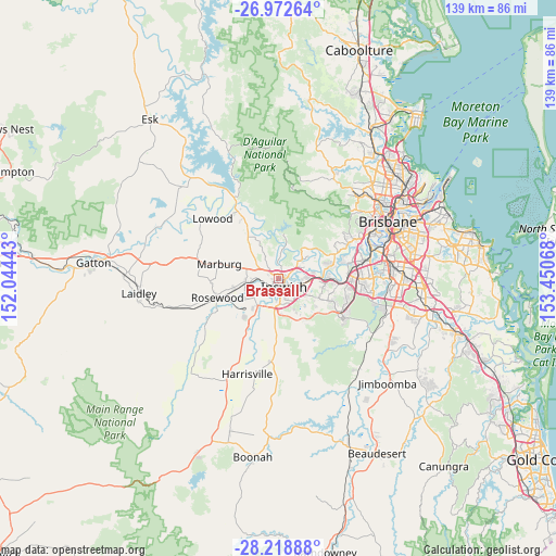
Brassall GPS coordinates[2]
27° 35' 51.108" South, 152° 44' 51.18" East
| Map corner | latitude | longitude |
|---|---|---|
| Upper-left | -26.97264°, | 152.04443° |
| Center: | -27.59753°, | 152.74755° |
| Lower-right: | -28.21888°, | 153.45068° |
| Map W x H: | 138.6×138.6 km | = 86.1×86.1mi |
| max Lat: | -10.58257° ⇑20.3% North |
| Brassall: | -27.59753° |
| min Lat: | ⇓79.7% South -43.31423° |
| min Long | Brassall | max Long |
| 113.53327° | 152.74755° | 153.61246° |
| W 86.2%⇐ | ⇒13.8% E |
Elevation
Elevation of Brassall is 25 m = 82 ft, and this is 97 m = 318 ft below average elevation for this country.
| Max E: |
1715 m = 5627 ft | 67.2% |
| Avg. | 122 m = 400 ft | |
| Brassall | 25 m = 82 ft | |
Min E: |
-2 m = -7 ft | 32.8% |
See also: Australia elevation on elevation.city.
Geographical zone
Brassall is located in South temperate zone (between Tropic of Capricorn and the Antarctic Circle). Distance of this Southern Tropic circle is 462.6 km =287.4 mi to North.| Distance of | km | miles | from Brassall |
|---|---|---|---|
| Equator | 3068.6 | 1906.7 | to North |
| Tropic Capricorn | 462.6 | 287.4 | to North |
| Antarctic Circle | 4332.6 | 2692.2 | to South |
| South Pole | 6938.5 | 4311.4 | to South |


Nearby cities:
15 places around Brassall: (largest is in red/bold)
• Basin Pocket
2.4 km =1.5 mi,  96°
96°
• Booval
4.5 km =2.8 mi,  112°
112°
• Chuwar
4.6 km =2.9 mi,  41°
41°
• Coalfalls
1.2 km =0.7 mi,  183°
183°
• East Ipswich
2.6 km =1.6 mi, 111°
• Ipswich
3.2 km =2 mi,  155°
155°
• Leichhardt
3.1 km =1.9 mi,  205°
205°
• Moores Pocket
2.9 km =1.8 mi,  90°
90°
• Newtown
3.6 km =2.2 mi,  125°
125°
• North Ipswich
1.5 km =0.9 mi, 113°
• One Mile
3.6 km =2.2 mi,  195°
195°
• Sadliers Crossing
1.7 km =1.1 mi,  186°
186°
• Tivoli
2.1 km =1.3 mi,  75°
75°
• Woodend
1 km =0.6 mi,  148°
148°
• Wulkuraka
3.1 km =1.9 mi,  233°
233°
Sources, notices
• [Note1] Compared only with cities in Australia existing in our database
• [Src1] Map data: © OpenStreetMap contributors (CC-BY-SA)
• [Src2] Other city data from geonames.org with taken over terms of usage.
• [Src3] Geographical zone / Annual Mean Temperature by Robert A. Rohde @ Wikipedia
