Fernvale geodata
Fernvale (Queensland) is a populated place; located in Australia in Australia/Brisbane (GMT+10) time zone. With population of 3,213 people, there are 2121 cities with bigger population in this country. Compared to other cities in Australia, 82.9% of cities are located further ↓South; 85.3% of cities are located further ←West and 52% of cities have lower elevation than Fernvale. Note1


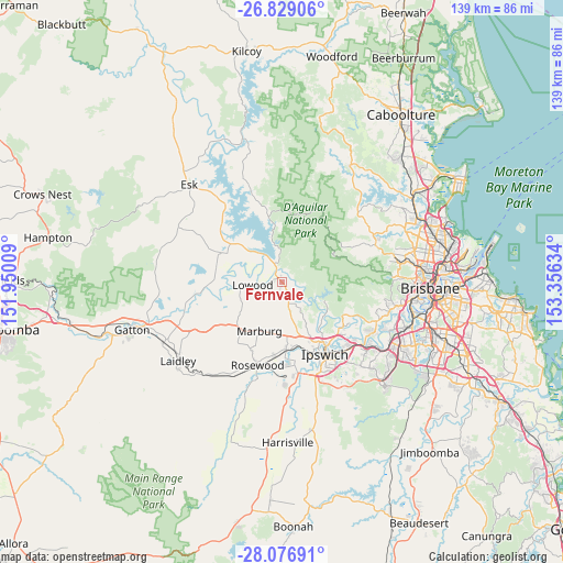
Fernvale GPS coordinates[2]
27° 27' 17.1" South, 152° 39' 11.556" East
| Map corner | latitude | longitude |
|---|---|---|
| Upper-left | -26.82906°, | 151.95009° |
| Center: | -27.45475°, | 152.65321° |
| Lower-right: | -28.07691°, | 153.35634° |
| Map W x H: | 138.7×138.7 km | = 86.2×86.2mi |
| max Lat: | -10.58257° ⇑17.1% North |
| Fernvale: | -27.45475° |
| min Lat: | ⇓82.9% South -43.31423° |
| min Long | Fernvale | max Long |
| 113.53327° | 152.65321° | 153.61246° |
| W 85.3%⇐ | ⇒14.7% E |
Elevation
Elevation of Fernvale is 48 m = 157 ft, and this is 74 m = 243 ft below average elevation for this country.
| Max E: |
1715 m = 5627 ft | 48% |
| Avg. | 122 m = 400 ft | |
| Fernvale | 48 m = 157 ft | |
Min E: |
-2 m = -7 ft | 52% |
See also: Australia elevation on elevation.city.
Geographical zone
Fernvale is located in South temperate zone (between Tropic of Capricorn and the Antarctic Circle). Distance of this Southern Tropic circle is 446.8 km =277.6 mi to North.| Distance of | km | miles | from Fernvale |
|---|---|---|---|
| Equator | 3052.7 | 1896.9 | to North |
| Tropic Capricorn | 446.8 | 277.6 | to North |
| Antarctic Circle | 4348.5 | 2702 | to South |
| South Pole | 6954.4 | 4321.3 | to South |


Nearby cities:
15 places around Fernvale: (largest is in red/bold)
• Brassall
18.4 km =11.4 mi,  149°
149°
• Brightview
17.5 km =10.9 mi,  253°
253°
• Chuwar
17.5 km =10.9 mi,  135°
135°
• Coominya
16.7 km =10.4 mi,  295°
295°
• Highvale
17.3 km =10.7 mi,  58°
58°
• Ironbark
11.5 km =7.1 mi,  170°
170°
• Karana Downs
18.4 km =11.4 mi,  124°
124°
• Lowood
7.7 km =4.8 mi,  261°
261°
• Marburg
13.6 km =8.5 mi,  204°
204°
• Minden
15.8 km =9.8 mi,  222°
222°
• Mount Crosby
17.8 km =11.1 mi, 122°
• Pine Mountain
11.6 km =7.2 mi,  156°
156°
• Tivoli
19.1 km =11.9 mi, 143°
• Walloon
16.8 km =10.4 mi,  176°
176°
• Wulkuraka
19 km =11.8 mi, 159°
Sources, notices
• [Note1] Compared only with cities in Australia existing in our database
• [Src1] Map data: © OpenStreetMap contributors (CC-BY-SA)
• [Src2] Other city data from geonames.org with taken over terms of usage.
• [Src3] Geographical zone / Annual Mean Temperature by Robert A. Rohde @ Wikipedia
