Lysterfield geodata
Lysterfield (Victoria) is a section of populated place; located in Australia in Australia/Melbourne (GMT+11) time zone. With population of 6,569 people, there are 1057 cities with bigger population in this country. Compared to other cities in Australia, 91% of cities are located further ↑North; 61.4% of cities are located further →East and 76.2% of cities have lower elevation than Lysterfield. Note1


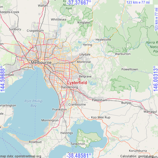
Lysterfield GPS coordinates[2]
37° 55' 59.988" South, 145° 18' 0" East
| Map corner | latitude | longitude |
|---|---|---|
| Upper-left | -37.37667°, | 144.59688° |
| Center: | -37.93333°, | 145.3° |
| Lower-right: | -38.48581°, | 146.00313° |
| Map W x H: | 123.3×123.3 km | = 76.6×76.6mi |
| max Lat: | -10.58257° ⇑91% North |
| Lysterfield: | -37.93333° |
| min Lat: | ⇓9% South -43.31423° |
| min Long | Lysterfield | max Long |
| 113.53327° | 145.3° | 153.61246° |
| W 38.6%⇐ | ⇒61.4% E |
Elevation
Elevation of Lysterfield is 140 m = 459 ft, and this is 18 m = 59 ft above average elevation for this country.
| Max E: |
1715 m = 5627 ft | 23.8% |
| Lysterfield | 140 m 459 ft | |
| Avg. | 122 m = 400 ft | |
Min E: |
-2 m = -7 ft | 76.2% |
See also: Australia elevation on elevation.city.
Geographical zone
Lysterfield is located in South temperate zone (between Tropic of Capricorn and the Antarctic Circle). Distance of this Southern Tropic circle is 1611.9 km =1001.6 mi to North.| Distance of | km | miles | from Lysterfield |
|---|---|---|---|
| Equator | 4217.8 | 2620.8 | to North |
| Tropic Capricorn | 1611.9 | 1001.6 | to North |
| Antarctic Circle | 3183.4 | 1978.1 | to South |
| South Pole | 5789.3 | 3597.3 | to South |


Nearby cities:
15 places around Lysterfield: (largest is in red/bold)
• Belgrave
5.3 km =3.3 mi,  62°
62°
• Belgrave Heights
3.9 km =2.4 mi,  78°
78°
• Belgrave South
2.9 km =1.8 mi,  90°
90°
• Boronia
7.6 km =4.7 mi,  348°
348°
• Endeavour Hills
6.1 km =3.8 mi,  216°
216°
• Ferntree Gully
5.4 km =3.4 mi,  355°
355°
• Ferny Creek
6.3 km =3.9 mi,  27°
27°
• Knoxfield
6.6 km =4.1 mi,  317°
317°
• Lysterfield South
3.6 km =2.2 mi, 220°
• Narre Warren North
5.7 km =3.5 mi,  165°
165°
• Rowville
5.8 km =3.6 mi,  270°
270°
• Scoresby
6.9 km =4.3 mi,  302°
302°
• Selby
7.5 km =4.7 mi, 75°
• Tecoma
5.2 km =3.2 mi,  49°
49°
• Upwey
4.7 km =2.9 mi,  38°
38°
Sources, notices
• [Note1] Compared only with cities in Australia existing in our database
• [Src1] Map data: © OpenStreetMap contributors (CC-BY-SA)
• [Src2] Other city data from geonames.org with taken over terms of usage.
• [Src3] Geographical zone / Annual Mean Temperature by Robert A. Rohde @ Wikipedia
