Upwey geodata
Upwey (Victoria) is a section of populated place; located in Australia in Australia/Melbourne (GMT+11) time zone. With population of 6,501 people, there are 1072 cities with bigger population in this country. Compared to other cities in Australia, 90.5% of cities are located further ↑North; 61.2% of cities are located further →East and 83.1% of cities have lower elevation than Upwey. Note1


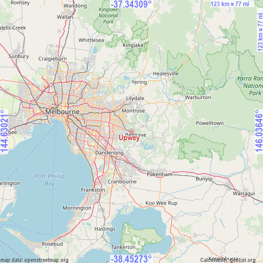
Upwey GPS coordinates[2]
37° 54' 0" South, 145° 19' 59.988" East
| Map corner | latitude | longitude |
|---|---|---|
| Upper-left | -37.34309°, | 144.63021° |
| Center: | -37.9°, | 145.33333° |
| Lower-right: | -38.45273°, | 146.03646° |
| Map W x H: | 123.4×123.4 km | = 76.7×76.7mi |
| max Lat: | -10.58257° ⇑90.5% North |
| Upwey: | -37.9° |
| min Lat: | ⇓9.5% South -43.31423° |
| min Long | Upwey | max Long |
| 113.53327° | 145.33333° | 153.61246° |
| W 38.8%⇐ | ⇒61.2% E |
Elevation
Elevation of Upwey is 219 m = 719 ft, and this is 97 m = 318 ft above average elevation for this country.
| Max E: |
1715 m = 5627 ft | 16.9% |
| Upwey | 219 m 719 ft | |
| Avg. | 122 m = 400 ft | |
Min E: |
-2 m = -7 ft | 83.1% |
See also: Australia elevation on elevation.city.
Geographical zone
Upwey is located in South temperate zone (between Tropic of Capricorn and the Antarctic Circle). Distance of this Southern Tropic circle is 1608.2 km =999.3 mi to North.| Distance of | km | miles | from Upwey |
|---|---|---|---|
| Equator | 4214.1 | 2618.5 | to North |
| Tropic Capricorn | 1608.2 | 999.3 | to North |
| Antarctic Circle | 3187.1 | 1980.4 | to South |
| South Pole | 5793 | 3599.6 | to South |


Nearby cities:
15 places around Upwey: (largest is in red/bold)
• Belgrave
2.2 km =1.4 mi,  124°
124°
• Belgrave Heights
3.1 km =1.9 mi,  162°
162°
• Belgrave South
3.7 km =2.3 mi,  180°
180°
• Boronia
5.7 km =3.5 mi,  310°
310°
• Ferntree Gully
3.7 km =2.3 mi,  297°
297°
• Ferny Creek
1.9 km =1.2 mi,  0°
0°
• Kallista
4.3 km =2.7 mi,  87°
87°
• Lysterfield
4.7 km =2.9 mi,  218°
218°
• Menzies Creek
6.1 km =3.8 mi,  107°
107°
• Olinda
6.3 km =3.9 mi,  27°
27°
• Sassafras
4 km =2.5 mi,  21°
21°
• Selby
4.8 km =3 mi, 112°
• Tecoma
1.1 km =0.7 mi, 108°
• The Basin
5.7 km =3.5 mi,  345°
345°
• The Patch
6.1 km =3.8 mi,  81°
81°
Sources, notices
• [Note1] Compared only with cities in Australia existing in our database
• [Src1] Map data: © OpenStreetMap contributors (CC-BY-SA)
• [Src2] Other city data from geonames.org with taken over terms of usage.
• [Src3] Geographical zone / Annual Mean Temperature by Robert A. Rohde @ Wikipedia
