Knoxfield geodata
Knoxfield (Victoria) is a section of populated place; located in Australia in Australia/Melbourne (GMT+11) time zone. With population of 7,254 people, there are 943 cities with bigger population in this country. Compared to other cities in Australia, 90.1% of cities are located further ↑North; 62% of cities are located further →East and 67.3% of cities have lower elevation than Knoxfield. Note1


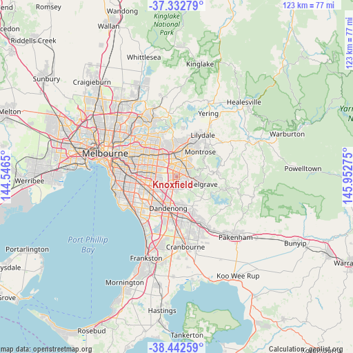
Knoxfield GPS coordinates[2]
37° 53' 23.208" South, 145° 14' 58.632" East
| Map corner | latitude | longitude |
|---|---|---|
| Upper-left | -37.33279°, | 144.5465° |
| Center: | -37.88978°, | 145.24962° |
| Lower-right: | -38.44259°, | 145.95275° |
| Map W x H: | 123.4×123.4 km | = 76.7×76.7mi |
| max Lat: | -10.58257° ⇑90.1% North |
| Knoxfield: | -37.88978° |
| min Lat: | ⇓9.9% South -43.31423° |
| min Long | Knoxfield | max Long |
| 113.53327° | 145.24962° | 153.61246° |
| W 38%⇐ | ⇒62% E |
Elevation
Elevation of Knoxfield is 90 m = 295 ft, and this is 32 m = 105 ft below average elevation for this country.
| Max E: |
1715 m = 5627 ft | 32.7% |
| Avg. | 122 m = 400 ft | |
| Knoxfield | 90 m = 295 ft | |
Min E: |
-2 m = -7 ft | 67.3% |
See also: Australia elevation on elevation.city.
Geographical zone
Knoxfield is located in South temperate zone (between Tropic of Capricorn and the Antarctic Circle). Distance of this Southern Tropic circle is 1607 km =998.5 mi to North.| Distance of | km | miles | from Knoxfield |
|---|---|---|---|
| Equator | 4212.9 | 2617.8 | to North |
| Tropic Capricorn | 1607 | 998.5 | to North |
| Antarctic Circle | 3188.2 | 1981.1 | to South |
| South Pole | 5794.1 | 3600.3 | to South |


Nearby cities:
15 places around Knoxfield: (largest is in red/bold)
• Bayswater
4.7 km =2.9 mi,  18°
18°
• Boronia
3.9 km =2.4 mi,  49°
49°
• Ferntree Gully
4.1 km =2.5 mi,  81°
81°
• Ferny Creek
7.4 km =4.6 mi, 84°
• Glen Waverley
7.6 km =4.7 mi,  279°
279°
• Heathmont
6.3 km =3.9 mi,  0°
0°
• Lysterfield
6.6 km =4.1 mi,  137°
137°
• Rowville
5 km =3.1 mi,  196°
196°
• Scoresby
1.8 km =1.1 mi,  231°
231°
• The Basin
7.4 km =4.6 mi, 53°
• Upwey
7.4 km =4.6 mi,  98°
98°
• Vermont South
6.9 km =4.3 mi,  301°
301°
• Wantirna
5.3 km =3.3 mi,  326°
326°
• Wantirna South
3 km =1.9 mi, 283°
• Wheelers Hill
5.9 km =3.7 mi,  258°
258°
Sources, notices
• [Note1] Compared only with cities in Australia existing in our database
• [Src1] Map data: © OpenStreetMap contributors (CC-BY-SA)
• [Src2] Other city data from geonames.org with taken over terms of usage.
• [Src3] Geographical zone / Annual Mean Temperature by Robert A. Rohde @ Wikipedia
