Killingworth geodata
Killingworth (New South Wales) is a section of populated place; located in Australia in Australia/Sydney (GMT+11) time zone. With population of 683 people, there are 4355 cities with bigger population in this country. Compared to other cities in Australia, 58.3% of cities are located further ↓South; 78.4% of cities are located further ←West and 59.2% of cities have higher elevation than Killingworth. Note1


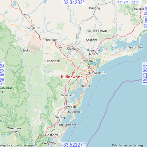
Killingworth GPS coordinates[2]
32° 56' 2.796" South, 151° 33' 21.492" East
| Map corner | latitude | longitude |
|---|---|---|
| Upper-left | -32.34202°, | 150.85285° |
| Center: | -32.93411°, | 151.55597° |
| Lower-right: | -33.52227°, | 152.2591° |
| Map W x H: | 131.2×131.2 km | = 81.5×81.5mi |
| max Lat: | -10.58257° ⇑41.7% North |
| Killingworth: | -32.93411° |
| min Lat: | ⇓58.3% South -43.31423° |
| min Long | Killingworth | max Long |
| 113.53327° | 151.55597° | 153.61246° |
| W 78.4%⇐ | ⇒21.6% E |
Elevation
Elevation of Killingworth is 33 m = 108 ft, and this is 89 m = 292 ft below average elevation for this country.
| Max E: |
1715 m = 5627 ft | 59.2% |
| Avg. | 122 m = 400 ft | |
| Killingworth | 33 m = 108 ft | |
Min E: |
-2 m = -7 ft | 40.8% |
See also: Australia elevation on elevation.city.
Geographical zone
Killingworth is located in South temperate zone (between Tropic of Capricorn and the Antarctic Circle). Distance of this Southern Tropic circle is 1056 km =656.2 mi to North.| Distance of | km | miles | from Killingworth |
|---|---|---|---|
| Equator | 3661.9 | 2275.4 | to North |
| Tropic Capricorn | 1056 | 656.2 | to North |
| Antarctic Circle | 3739.2 | 2323.4 | to South |
| South Pole | 6345.1 | 3942.7 | to South |


Nearby cities:
15 places around Killingworth: (largest is in red/bold)
• Argenton
7 km =4.3 mi,  90°
90°
• Barnsley
2.6 km =1.6 mi, 88°
• Blackalls Park
7.6 km =4.7 mi,  162°
162°
• Boolaroo
6.8 km =4.2 mi,  102°
102°
• Booragul
6.8 km =4.2 mi,  132°
132°
• Cameron Park
5.5 km =3.4 mi,  56°
56°
• Edgeworth
5.7 km =3.5 mi,  79°
79°
• Fassifern
6 km =3.7 mi,  154°
154°
• Fennell Bay
7.7 km =4.8 mi, 147°
• Holmesville
3.2 km =2 mi,  52°
52°
• Mulbring
7.4 km =4.6 mi,  296°
296°
• Speers Point
7.3 km =4.5 mi,  116°
116°
• Teralba
5.5 km =3.4 mi, 131°
• West Wallsend
4.6 km =2.9 mi,  33°
33°
• Woodrising
7.5 km =4.7 mi,  140°
140°
Sources, notices
• [Note1] Compared only with cities in Australia existing in our database
• [Src1] Map data: © OpenStreetMap contributors (CC-BY-SA)
• [Src2] Other city data from geonames.org with taken over terms of usage.
• [Src3] Geographical zone / Annual Mean Temperature by Robert A. Rohde @ Wikipedia
