Kealba geodata
Kealba (Victoria) is a section of populated place; located in Australia in Australia/Melbourne (GMT+11) time zone. With population of 3,174 people, there are 2146 cities with bigger population in this country. Compared to other cities in Australia, 85.7% of cities are located further ↑North; 68.7% of cities are located further →East and 60.7% of cities have lower elevation than Kealba. Note1


Kealba GPS coordinates[2]
37° 44' 13.56" South, 144° 49' 41.88" East
| Map corner | latitude | longitude |
|---|---|---|
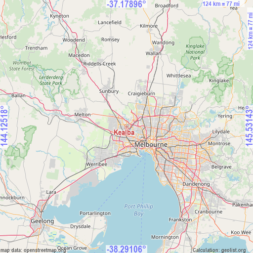
| Upper-left | -37.17896°, | 144.12518° |
| Center: | -37.7371°, | 144.8283° |
| Lower-right: | -38.29106°, | 145.53143° |
| Map W x H: | 123.7×123.7 km | = 76.9×76.9mi |
| max Lat: | -10.58257° ⇑85.7% North |
| Kealba: | -37.7371° |
| min Lat: | ⇓14.3% South -43.31423° |
| min Long | Kealba | max Long |
| 113.53327° | 144.8283° | 153.61246° |
| W 31.3%⇐ | ⇒68.7% E |
Elevation
Elevation of Kealba is 66 m = 217 ft, and this is 56 m = 184 ft below average elevation for this country.
| Max E: |
1715 m = 5627 ft | 39.3% |
| Avg. | 122 m = 400 ft | |
| Kealba | 66 m = 217 ft | |
Min E: |
-2 m = -7 ft | 60.7% |
See also: Australia elevation on elevation.city.
Geographical zone
Kealba is located in South temperate zone (between Tropic of Capricorn and the Antarctic Circle). Distance of this Southern Tropic circle is 1590.1 km =988 mi to North.| Distance of | km | miles | from Kealba |
|---|---|---|---|
| Equator | 4196 | 2607.3 | to North |
| Tropic Capricorn | 1590.1 | 988 | to North |
| Antarctic Circle | 3205.2 | 1991.6 | to South |
| South Pole | 5811.1 | 3610.8 | to South |


Nearby cities:
15 places around Kealba: (largest is in red/bold)
• Airport West
4.9 km =3 mi,  73°
73°
• Albion
4.9 km =3 mi,  191°
191°
• Ardeer
4.9 km =3 mi,  208°
208°
• Avondale Heights
4.1 km =2.5 mi,  132°
132°
• Cairnlea
4.3 km =2.7 mi,  235°
235°
• Delahey
4.9 km =3 mi,  293°
293°
• Keilor
2.3 km =1.4 mi,  11°
11°
• Keilor Downs
2.3 km =1.4 mi,  311°
311°
• Keilor East
3.3 km =2.1 mi,  81°
81°
• Keilor Lodge
4.7 km =2.9 mi,  331°
331°
• Keilor Park
3 km =1.9 mi,  50°
50°
• Kings Park
4.5 km =2.8 mi,  274°
274°
• Saint Albans
2.5 km =1.6 mi,  279°
279°
• St Albans
2.6 km =1.6 mi,  250°
250°
• Sunshine North
3.6 km =2.2 mi,  180°
180°
Sources, notices
• [Note1] Compared only with cities in Australia existing in our database
• [Src1] Map data: © OpenStreetMap contributors (CC-BY-SA)
• [Src2] Other city data from geonames.org with taken over terms of usage.
• [Src3] Geographical zone / Annual Mean Temperature by Robert A. Rohde @ Wikipedia
