Clarence Town geodata
Clarence Town (New South Wales) is a populated place; located in Australia in Australia/Sydney (GMT+11) time zone. With population of 1,943 people, there are 2945 cities with bigger population in this country. Compared to other cities in Australia, 61.1% of cities are located further ↓South; 81.3% of cities are located further ←West and 68.6% of cities have higher elevation than Clarence Town. Note1


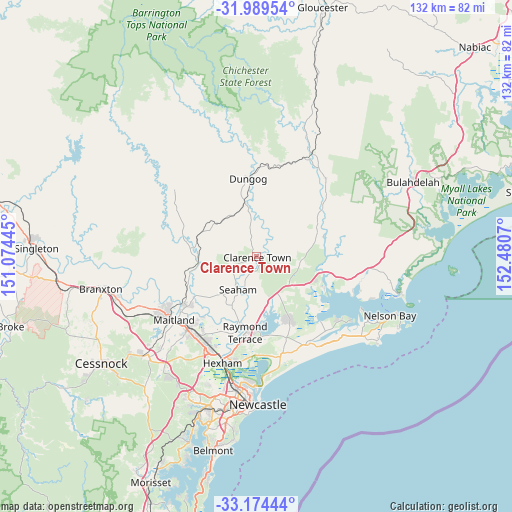
Clarence Town GPS coordinates[2]
32° 35' 2.22" South, 151° 46' 39.252" East
| Map corner | latitude | longitude |
|---|---|---|
| Upper-left | -31.98954°, | 151.07445° |
| Center: | -32.58395°, | 151.77757° |
| Lower-right: | -33.17444°, | 152.4807° |
| Map W x H: | 131.7×131.7 km | = 81.8×81.8mi |
| max Lat: | -10.58257° ⇑38.9% North |
| Clarence Town: | -32.58395° |
| min Lat: | ⇓61.1% South -43.31423° |
| min Long | Clarence Town | max Long |
| 113.53327° | 151.77757° | 153.61246° |
| W 81.3%⇐ | ⇒18.7% E |
Elevation
Elevation of Clarence Town is 24 m = 79 ft, and this is 98 m = 322 ft below average elevation for this country.
| Max E: |
1715 m = 5627 ft | 68.6% |
| Avg. | 122 m = 400 ft | |
| Clarence Town | 24 m = 79 ft | |
Min E: |
-2 m = -7 ft | 31.4% |
See also: Australia elevation on elevation.city.
Geographical zone
Clarence Town is located in South temperate zone (between Tropic of Capricorn and the Antarctic Circle). Distance of this Southern Tropic circle is 1017.1 km =632 mi to North.| Distance of | km | miles | from Clarence Town |
|---|---|---|---|
| Equator | 3623 | 2251.2 | to North |
| Tropic Capricorn | 1017.1 | 632 | to North |
| Antarctic Circle | 3778.2 | 2347.7 | to South |
| South Pole | 6384.1 | 3966.9 | to South |


Nearby cities:
15 places around Clarence Town: (largest is in red/bold)
• Bolwarra Heights
22.2 km =13.8 mi,  234°
234°
• Brandy Hill
14 km =8.7 mi,  213°
213°
• Dungog
20.1 km =12.5 mi,  353°
353°
• Duns Creek
14.6 km =9.1 mi,  247°
247°
• Karuah
18.8 km =11.7 mi,  114°
114°
• Largs
21 km =13 mi, 232°
• Medowie
19.4 km =12.1 mi,  154°
154°
• Morpeth
21.4 km =13.3 mi,  219°
219°
• Nelsons Plains
18.7 km =11.6 mi,  192°
192°
• Paterson
15.3 km =9.5 mi,  260°
260°
• Raworth
22.4 km =13.9 mi, 222°
• Raymond Terrace
19.7 km =12.2 mi, 187°
• Seaham
9.9 km =6.2 mi, 208°
• Vacy
20.4 km =12.7 mi,  286°
286°
• Wallalong
17.3 km =10.7 mi, 224°
Sources, notices
• [Note1] Compared only with cities in Australia existing in our database
• [Src1] Map data: © OpenStreetMap contributors (CC-BY-SA)
• [Src2] Other city data from geonames.org with taken over terms of usage.
• [Src3] Geographical zone / Annual Mean Temperature by Robert A. Rohde @ Wikipedia
