Hay Point geodata
Hay Point (Queensland) is a populated place; located in Australia in Australia/Brisbane (GMT+10) time zone. With population of 1,263 people, there are 3511 cities with bigger population in this country. Compared to other cities in Australia, 93% of cities are located further ↓South; 55.8% of cities are located further ←West and 91.8% of cities have higher elevation than Hay Point. Note1


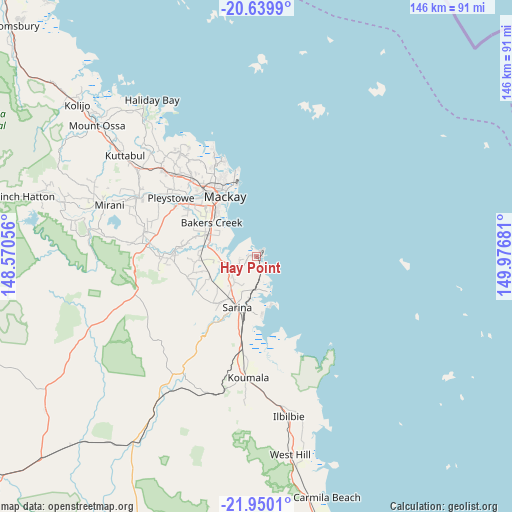
Hay Point GPS coordinates[2]
21° 17' 47.256" South, 149° 16' 25.248" East
| Map corner | latitude | longitude |
|---|---|---|
| Upper-left | -20.6399°, | 148.57056° |
| Center: | -21.29646°, | 149.27368° |
| Lower-right: | -21.9501°, | 149.97681° |
| Map W x H: | 145.7×145.7 km | = 90.5×90.5mi |
| max Lat: | -10.58257° ⇑7% North |
| Hay Point: | -21.29646° |
| min Lat: | ⇓93% South -43.31423° |
| min Long | Hay Point | max Long |
| 113.53327° | 149.27368° | 153.61246° |
| W 55.8%⇐ | ⇒44.2% E |
Elevation
Elevation of Hay Point is 8 m = 26 ft, and this is 114 m = 374 ft below average elevation for this country.
| Max E: |
1715 m = 5627 ft | 91.8% |
| Avg. | 122 m = 400 ft | |
| Hay Point | 8 m = 26 ft | |
Min E: |
-2 m = -7 ft | 8.2% |
See also: Australia elevation on elevation.city.
Geographical zone
Hay Point is located in South Torrid zone (between Equator and Tropic of Capricorn). Distance of this Southern Tropic circle is 238 km =147.9 mi to South.| Distance of | km | miles | from Hay Point |
|---|---|---|---|
| Equator | 2367.9 | 1471.3 | to North |
| Tropic Capricorn | 238 | 147.9 | to South |
| Antarctic Circle | 5033.2 | 3127.5 | to South |
| South Pole | 7639.1 | 4746.7 | to South |


Nearby cities:
15 places around Hay Point: (largest is in red/bold)
• Alligator Creek
8.7 km =5.4 mi,  241°
241°
• Armstrong Beach
16.9 km =10.5 mi,  174°
174°
• Bakers Creek
15.7 km =9.8 mi,  302°
302°
• East Mackay
18.2 km =11.3 mi,  333°
333°
• Grasstree Beach
8.2 km =5.1 mi,  155°
155°
• Mackay
19.5 km =12.1 mi,  324°
324°
• Mackay City
19.1 km =11.9 mi, 331°
• Mackay Harbour
21.8 km =13.5 mi,  342°
342°
• Mount Pleasant
23.1 km =14.4 mi, 329°
• North Mackay
21.9 km =13.6 mi, 333°
• Ooralea
18.9 km =11.7 mi, 316°
• Sarina
14.9 km =9.3 mi,  203°
203°
• Sarina Beach
10.8 km =6.7 mi, 160°
• South Mackay
17.9 km =11.1 mi, 326°
• West Mackay
19.6 km =12.2 mi, 323°
Sources, notices
• [Note1] Compared only with cities in Australia existing in our database
• [Src1] Map data: © OpenStreetMap contributors (CC-BY-SA)
• [Src2] Other city data from geonames.org with taken over terms of usage.
• [Src3] Geographical zone / Annual Mean Temperature by Robert A. Rohde @ Wikipedia
