Grantham geodata
Grantham (Queensland) is a populated place; located in Australia in Australia/Brisbane (GMT+10) time zone. With population of 627 people, there are 4498 cities with bigger population in this country. Compared to other cities in Australia, 80% of cities are located further ↓South; 83.3% of cities are located further ←West and 72.9% of cities have lower elevation than Grantham. Note1


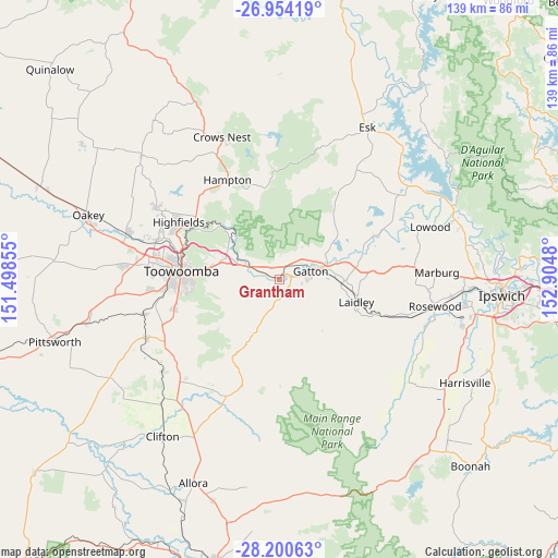
Grantham GPS coordinates[2]
27° 34' 45.048" South, 152° 12' 6.012" East
| Map corner | latitude | longitude |
|---|---|---|
| Upper-left | -26.95419°, | 151.49855° |
| Center: | -27.57918°, | 152.20167° |
| Lower-right: | -28.20063°, | 152.9048° |
| Map W x H: | 138.6×138.6 km | = 86.1×86.1mi |
| max Lat: | -10.58257° ⇑20% North |
| Grantham: | -27.57918° |
| min Lat: | ⇓80% South -43.31423° |
| min Long | Grantham | max Long |
| 113.53327° | 152.20167° | 153.61246° |
| W 83.3%⇐ | ⇒16.7% E |
Elevation
Elevation of Grantham is 117 m = 384 ft, and this is 5 m = 16 ft below average elevation for this country.
| Max E: |
1715 m = 5627 ft | 27.1% |
| Avg. | 122 m = 400 ft | |
| Grantham | 117 m = 384 ft | |
Min E: |
-2 m = -7 ft | 72.9% |
See also: Australia elevation on elevation.city.
Geographical zone
Grantham is located in South temperate zone (between Tropic of Capricorn and the Antarctic Circle). Distance of this Southern Tropic circle is 460.6 km =286.2 mi to North.| Distance of | km | miles | from Grantham |
|---|---|---|---|
| Equator | 3066.5 | 1905.4 | to North |
| Tropic Capricorn | 460.6 | 286.2 | to North |
| Antarctic Circle | 4334.7 | 2693.5 | to South |
| South Pole | 6940.5 | 4312.6 | to South |


Nearby cities:
15 places around Grantham: (largest is in red/bold)
• Adare
11.8 km =7.3 mi,  51°
51°
• East Toowoomba
22.4 km =13.9 mi,  272°
272°
• Forest Hill
15.3 km =9.5 mi,  95°
95°
• Gatton
7.7 km =4.8 mi,  72°
72°
• Glenore Grove
20.2 km =12.6 mi,  75°
75°
• Helidon
8.2 km =5.1 mi,  290°
290°
• Laidley
19.8 km =12.3 mi,  107°
107°
• Mount Lofty
22.9 km =14.2 mi,  279°
279°
• Murphys Creek
19.3 km =12 mi,  311°
311°
• Placid Hills
3.6 km =2.2 mi,  56°
56°
• Plainland
21.2 km =13.2 mi,  86°
86°
• Prince Henry Heights
21 km =13 mi, 278°
• Rangeville
21.9 km =13.6 mi, 268°
• Spring Creek
19 km =11.8 mi,  42°
42°
• Withcott
17.7 km =11 mi, 279°
Sources, notices
• [Note1] Compared only with cities in Australia existing in our database
• [Src1] Map data: © OpenStreetMap contributors (CC-BY-SA)
• [Src2] Other city data from geonames.org with taken over terms of usage.
• [Src3] Geographical zone / Annual Mean Temperature by Robert A. Rohde @ Wikipedia
